Linear coordinate system |


|
|
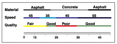
A linear coordinate system is a way of applying spatial data using relative locations along an existing line object. Linear coordinate systems are used for a number of reasons: - registration of events along line objects: for example, the places of traffic accidents can be recorded using an expression like «27 meters east of kilometer sign 35 on the M4 highway». - measuring sensors record the position on the line (track of movement or the axis of an existing object) by measuring distance or time along the line - a gas pipeline, road, channel, etc. - linking sets of various attributes with parts of linear objects without necessity of splitting the main object each time when the values of attributes change. The figure shows an example of storing attributes with a binding to a linear object:
The use of a linear coordinate system provides storage of additional attributes about roads without splitting roads into many tiny objects - parcels with the same attributes value. |