GIS Server data |


|
|
Open data on the GIS Server dialog is intended to open or add into the current document the data located on remote storage media.
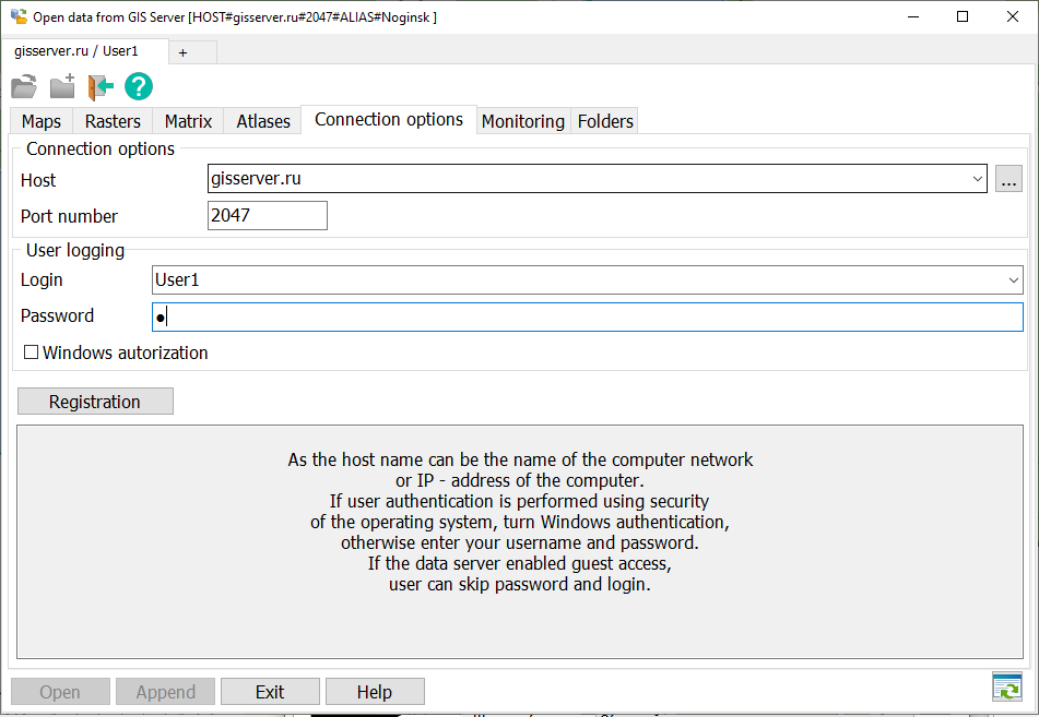
To connect to the server, fill the connection settings and data for user registration. The host name can be specified in a symbolic form or as IP - address of the computer on which the program of the GIS Server is started. As the host name you can set a name of a computer in a local area network. To select the host name you can use the choice button. Except for the server address the number of port for connection is specified. By default number of port is 2047. Access of the user to data is made by the username and password, or with using the data of his account in the security policy of the domain or operating system of a local computer. If user authentication is performed using the security system of operating system (or Active Directory), enable the mode Windows Authentication. If the user authentication is made by login and password, enter your login and password. If to data of a server the guest access is enabled, the password and login can be not entered. Connection to the server and user registration is performed when you press the Register button. If registration was successfully, bookmarks are filled with data to which the user has access. To connect to another server, select the bookmark +. On the appeared bookmark New connection, fill settings for the new connection. If in the chosen connection there are no open data, the user can close connection by clicking the button of close X, located on header of a bookmark. Also it is possible for given connection to change the user or to choose other server.
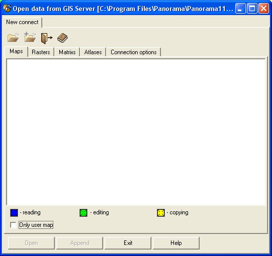
The data accessible to the user on each server are divided into types: Maps, Rasters, Matrixes and Atlases. Names of data are highlighted by black color and accompanied by the picture, allowing to define a type of access to them. The toolbar buttons duplicate the buttons located at the form bottom. The name of a current map is indicated in the window caption. If there is no current map, the Add button is disabled. By double click of the mouse on the chosen data they are added to a current map. The dialog provides a search for documents (nodes) according to the assigned template. When you press the Ctrl+F key combination on the keyboard, you must enter a character or a group of characters in the search line. If you set the character * (asterisk) in the template string, then the nodes containing all the specified characters will be selected. For example, "noginsk*military". If the search template contains the special character ?, then a node is searched for, the name of which contains at least one of the phrases: "noginsk?military". To perform a search after typing characters, press the Enter button. Found documents can be opened or added to the open map by pressing the corresponding dialog buttons.
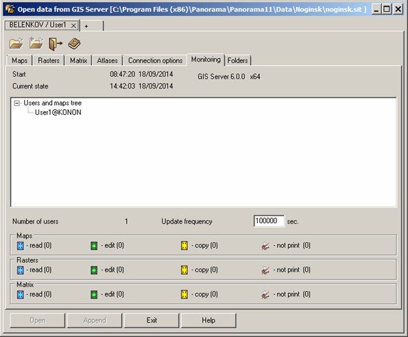
In the Monitoring bookmark there is displayed the start time of the program and its duration. The list of the connected users and lists of open data is displayed lower. For each user the name of the computer and through a colon the user name are indicated. For open data the access mode is specified. The blue small square means the permission for viewing, green - for editing, yellow - for copying. There is possible a combination of modes (editing and copying, etc.).
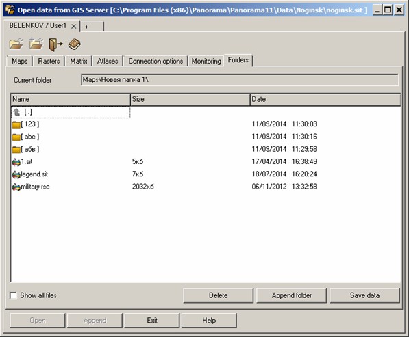
At the end of the list there are indicated the number of connected users and statistics for each type of open data. Information on the main form is updated with the predetermined frequency. At start of the program the frequency of updating is 5 seconds. The user of the program can set other value. The Folder bookmark carries out a role of the file manager and allows to view the presence of folders and files on the GIS Server, to sort them by different parameters, to carry out addition and deleting of catalogues and files.
Line the Current folder is convenient for navigation via folders and files. By clicking the mouse into one of the listed names we receives the unwrapped list of folders and files which belong to the chosen directory on the server. If the switch Show all files is in the included status (check mark), the list contains all aliases of all available folders and files on the server, and not only with the map, sit, sitx, rsc, mtw, mtq, rsw. The line [...] is intended for a raising onto level above. To add a folder onto the server the button serves the Add folder or the key F7 of the keyboard, to add files onto the server the button is used Save data. To delete the files and folders there is provided the button Delete or it is possible to use keys F8 or Delete. To remove several files, use multiple selection - by means of a combination of Shift key and the left mouse button on the name of first and the last file from the list. For a single selection you need to click on each file while holding down the Ctrl key. To mark all folders and files at once it is possible by simultaneously pressing the Shift key and *. Sorting of files is performed by name, size or date of creation - by clicking in a corresponding column of the folders table.
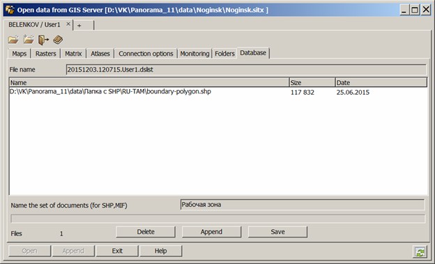
For storage of data sets on the server the Databank of digital maps and remote sensing data is created. In the dialog bookmark of opening the data on the GIS Server "Database" there is offered the toolkit for loading files of various formats which are supported by the system.
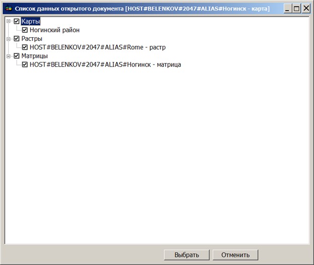
Filename of the list of downloadable sets is formed automatically and contains date and time of preparation of the data for transmission, and also a name of the registered user. To add files into the list it is possible to use the Append button or execute dragging operation onto the form of folders and files by using Windows Explorer. For deleting files and folders the Delete button is provided. To delete several files, there is used the multiple selection - using a combination of the Shift key and left-click on the name of first and the last file from the list. For single selection it is necessary to click on each file, hold down the Ctrl key. It is possible to select all files and folders at once by simultaneously pressing the Shift and * keys. For loading files onto the server it is necessary to choose the data group defining a place of storage of materials in storehouse. By default the data group is defined automatically. Files of type SHP and MIF/MID are stored in the Databank in the united collection, therefore for their placing it is required to specify the name of a set of documents. To update Databank the data sets can be used which are included into the current open document. The choice of the data for updating is made from records of the data tree of dialog the Data list which is activated by the Open map button. Maps before loading are converted into format SXF. The chosen documents are transferred to the table of dialog of opening the data on the GIS Server of the Databank bookmark.
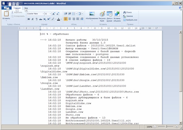
Upon termination of process of saving or updating the list of data into the bank on the screen the loading log is displayed:
The exit from dialog is carried out on closing the form or by the Exit button. |