Union of selected polygon objects |


|
|
Setting parameters of processing
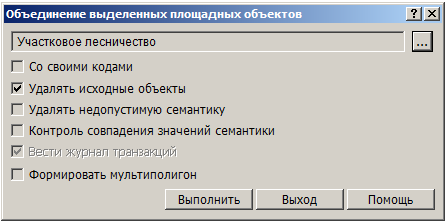
By default, the merged objects will look like the object specified in the upper field of the dialog. If you need to change the type of object, press the button «…».
When the option «By own code» is selected, only objects of the same type will be united, preserving the type of source objects. At objects uniting, the areal uniting the metrics of objects and semantic characteristics of objects is carried out.The admissibility of semantic characteristics is determined by the list of acceptable semantics for the selected type of united objects, specified in the digital classifier of the map (on the Objects - Semantics bookmark). If you select the «Delete incorrect semantics» option, all incorrect semantic characteristics will be removed. When you select the option «Control of semantics values coincidence», before uniting, the values of the corresponding semantics are checked for equality. When detecting the inconsistent values of the semantics of the analyzed pair of objects, the uniting is not performed. The absence of the value of the checked semantics in one of the objects of the analyzed pair is not a contradiction - this semantics is added into the united object. If the option «Control of semantics values coincidence» is disabled, then semantics from the first object of the analyzed pair is written into the united object. Semantics missing in the first object are added from the second object. If you select the «Create multipolygon» option, all the contours remaining after the objects uniting (including not united) will be united into one multipolygon.
Execution order
The process is interrupted by pressing the «Exit» button. The cancellation of the objects uniting is performed using the Return on step back mode.
|