Creation of user map |


|
|
Dialogue is a component of the Master of loading of the figures files received in field conditions by means of geodetic devices, equipped by means of digital processing. The master of loading of the figures files received by means of geodetic devices will start from a mode: Import from... /Files of geodesic gears. Necessary conditions of the work beginning of the Master: - The task: Import of geodetic measurements should be started from the main menu of the program (File/Import from …/Files of geodesic gears), thus all windows with cartographical data should be closed. - After loading files of the figures received by means of geodetic devices, in the task: Import of geodetic measurements and saving the results of processing in files .TEO or .TPR the name of EXIT button varies onto FURTHER. After pressing the FURTHER button of the dialogue: Import of geodetic measurements is started the Master of loading and Choice of mode of data processing dialog appears. - A choice between two modes of processing of the information is given to the User in Choice of mode of data processing dialogue: Construction and equalizing theodolite (tacheometric) course or Decision of direct geodetic tasks. By pressing the FURTHER button the dialogue: Choice of mode of data processing the Master of loading is started and Creation of user map dialog appears.
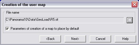
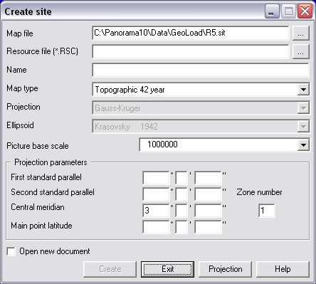
BACK button of Creation of user map dialog returns you into dialog: the Choice of a mode of the user map. User must specify a file name of a created user map for drawing on the map the results of construction and equalizing theodolite (tacheometric) a course or the decision of direct geodetic tasks in the subsequent. The user map with following parameters is created by default: - map type - the large-scale plan; - scale - 1 : 500; - a file name of the classifier - map500.rsc. If necessary creations of the user map with other characteristics switch-off a tick: Parameters of map creation to set by default. By pressing the FURTHER button of the dialog: Creation of the user map the expanded dialog: Creation of the user map opens for input of parameters of a created map.
After finishing of dialog: Creation of user map automatically window of the document with the created user map opens, the Geodetic calculations task with active modes: Construction and equalizing of theodolite (tacheometric) course or Decision of direct geodetic tasks is started. |