Print the map fragment by template |


|
|
The printing procedure for chosen digital vector map fragment with design by template is intended for fast forming the typical graphics documents. It is necessary to specify printed map area and by means of Print frame with template dialogue to specify parameters of created registration: the map filename, design conventional signs library (the classifier), the registration template filename after activization mode. The registration template contents (its image at printing) is allocated in the right part of the dialog. The registration template contents edition may be executed by pressing the Edit button at desire(it is possible to add, to delete or to change the file components. It is possible to create the new template file by use Create button if any of present templates does not satisfy you. There is fulfill a return to the printed map area choice mode by <<Back button. Then digital vector map standard print dialog will started by Next>> button. You may substitute printing area, set the printer parameters or produce printing of the created document directly by pressing the appropriate dialog buttons. The document registration is created as a separate user map and is attached to the chosen area immediately after creation automatically. The chosen printing area extends during registration creation on the value of the indent up to the external framework specified in field RSCFRAME of the registration template. The registration template is a text file with the FRM extension. It is possible to create registration template file by use any Windows text editor (for example, WordPad) beforehand manually or by pressing Create button in Map border dialog automatically. The design conventional signs libraries (.rsc) are created beforehand. It is possible to use one of standard design conventional signs libraries delivered together with the system or to create the own library for formation the specialized graphics documents registration. The registration template file may contain references only on object codes which are present in the design library used in aggregate with this template. If you use a text editor for template file creation you must observe the following rules: - The file should begin by FRAME key field. - All keywords should contain the Latin letters only and start from the first string position. - The presence empty strings or strings starting by the comment tag (the symbol «/») is admitted. - The string is considered as the comment and is not exposed to processing if its beginning is not a keyword (does not enter into the standard list of allowable key fields). In this connection it is necessary to concern with special attention to correct of keywords input. - The symbol «.» should be at the beginning of each keyword (except for FRAME). - The classification code of the object follows after the keyword. The classification code should necessarily be present at the design convectional sign library (classifier, on which the marginal representation registration is created).
The allowable keywords list: 1. .RSCFRAME (Framework) 2. .RSCTEXT (Text) 3. .RSCLINE (Line)
By use the field .RSCFRAME it is constructed the rectangle stand out on the specified distance from overall dimensions of the chosen area (an external framework) in registration, the internal framework of the chosen area is plotted and the image between internal and external frameworks is cleaned by the poligon object of the indicated code. Command format: .RSCFRAME P1 P2 P3 P4, where: P1 - external framework classification code (line object). P2 - distance in mm. between internal and external frameworks. P3 - classification code of a strip between internal and external frameworks (poligon object). P4 – internal framework classification code.
FOR EXAMPLE: .RSCFRAME 102 5.0 203 101 By use the field .RSCTEXT the titles are created in registration.
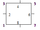
Command format: .RSCTEXT P1 P2 P3 P4 P5 P6 P7 P8, where: P1 - title classification code. P2 - reference point number (1-8 – sheet overall dimension points, see scheme). P3,P4 – coordinates of the first point (in mm. concerning a reference point). P5,P6 – coordinates of the second point (in mm. concerning a reference point). P7 – text alignment direction (0-at the left, 1- on centre, 2- on the right). P8 – Text.
FOR EXAMPLE: .RSCTEXT 320 4 -6 -10 -6 10 1 SITUATION ON 12.07.2001 The text in the template should be described by two points. The first point is indicated for binding, the second - for the direction definition (text orientation) when you describe text that is aligned by the first point (by the left edge). The binding will be produced on the second point, the first point is used for the direction definition assign when you describe text that is aligned by the second point (by the right edge) . The binding is produced by the centre, the coordinates of the first and second points are specified on both sides from a binding point on identical distance when you describe text that is aligned by centre. The symbol ~ is served for the carry line denotation at plotting the text in some lines.
FOR EXAMPLE: .RSCTEXT 320 4 -6 -10 -6 10 1 WORKING MAP ~ OF THE OPERATING ATTENDANT By use the field .RSCLINE the lines are created in registration. Command format: .RSCLINE P1 P2 P3 P4 P5, where: P1 - line classification code. P3,P4 – coordinates of the first point (in mm concerning a southwest corner of the selected area). P5,P6 – coordinates of the second point (in mm concerning a southwest corner of the selected area).
FOR EXAMPLE: .RSCLINE 101 -30 40 -90 40 By use the field .GEOTEXT the geodetic grid exits labels are created in registration. Command format: . GEOTEXT P1 P2 P3, where: P1 - label classification code. P2 – grid step (the whole degrees). P3 - the label indent from the framework in mm. (P3 - the indent of the label from the framework in mm.)
FOR EXAMPLE: .GEOTEXT 315 4 0.3 The registration template file example. FRAME / Operative attendant working map registration .RSCFRAME 102 5.0 203 101 .RSCTEXT 320 4 -6 -10 -6 10 1 SITUATION ON 12.07.2001 .RSCTEXT 321 5 -6 -20 -6 -6 2 NON SECRETLY .RSCTEXT 323 5 -10 -20 -10 -6 2 COPIES № .RSCTEXT 321 8 12 -10 12 10 1 OPERATIVE ATTENDANT .RSCTEXT 322 8 5 0 5 20 0 __________ V.IVANOV .GEOTEXT 315 4 0.3 END
|