Metric

Print Previous page Top page Next page


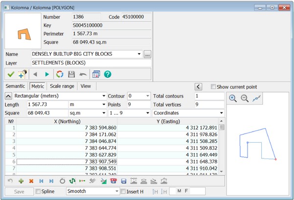
Displaying the object metric (sub-object) includes a number of statistical characteristics, as well as the coordinates and heights of its points and a schematic displaying the contour.


The following characteristics of object (subobject) are displayed:

- number of subobjects in the object;

- number of the displayed subobject (object has number 0);

- number of points in the object (subobject);

- distance between a current and next point of the object (subobject);

- directional angle, azimuth, left rotary angle, right rotary angle from the current to the next point of the object (subobject) and rhumb.


The coordinates of the metric's points can be displayed and edited in different units:

- in meters in a rectangular coordinate system;

- in pixels in a rectangular coordinate system;

- in radians in the geodetic coordinate system;

- in degrees with an accuracy of 1E-6 - 1E-7 in the geodetic system of coordinates;

- in degrees, minutes, seconds in the geodetic coordinate system.


When changing the coordinates of an object by changing the distance and angle, the coordinates of the point following the current one are corrected.

The coordinates of the first point of the metric cannot be corrected by this method.

If the metric of the object is the two-dimensional one, then you can add height to the coordinates. For this purpose it is required:

- expand the window of help information about the object and enable the Insert H mode or select the corresponding item Insert H of the pop-up menu;

- enter the height value in the field and press the Enter key. This value will be set to all points of the object and its subobjects. If the height value is not set, then the height pseudocode is written. Using the buttons , you can decrease and increase, respectively, the height value by the amount specified in the input field.


In order to add a metric characteristic, it is necessary to choose modes or . Into the table the corresponding column will be added. The characteristic has an integer, and - a real representation of the value.


Further, by editing, you can set different heights in specific points of the object.

To edit the heights in the metric of an object, you must first expand the reference information window about the object. This can be done by clicking the right mouse button above the dialog and selecting the Full-screen Object Information item in the pop-up menu, as well as by double-clicking the left mouse button above the dialog title.

Deleting the selected coordinates of the object by the list. When coordinates are selected in the table, the selected area is synchronously highlighted on the scheme.


Modes of operation with the object metric


Undo the last operation

Canceling the last operation

Current point duplicate

Duplicating the selected point

Current point delete

Deleting one or more selected points

First button

Go to the first point of the object

Last button

Go to the last point of the object

Close line

Closing the contour of an object. If the first and last points of the contour are located at a distance of more than 1 dm between each other, then one more point is added to close the contour of the object, otherwise the coordinates of the first point are recorded into the coordinates of the last point.

Change the direction

Changing the direction of digitization of an object's metric, including subobjects

Set first point

Setting the selected metric point of a closed object (subobject)  the first one

Subject delete

Deleting the current subobject

Go to current point on map

Go to the current point on the map

Save coordinates and metadata

Saving coordinates and metadata to format files:TXT, MAT, XYH, XLS

Save object

Saving an object to files of the following formats: SHP/DBF, OGC KML, GeoJSON

Take the height of the matrix

Setting the height from the matrix

Calculation of heights on spline

Height interpolation by spline

Calculation of heights from the beginning to the end of the line

Interpolation of heights from the beginning to the end


Additional pop-up menu modes


Show Layer/Defined objects

Enabling/Disabling the visibility of objects of this layer or a given type on the map

Multiobject sign

Installation/Removing the multi-object attribute from an object

The accuracy of the coordinates

Setting the accuracy of the coordinates display:

- Lower (decimeters);

- Lower (centimeters);

- Highly (millimeters);

- Maximum (microns)

Assign selected loop to main

Assigning the selected contour to the main one

Delete all subobjects

Deleting all subobjects

Height relative to surface

Setting the relative height to the H coordinate

Assign selected height all points

Assigning height to all points of the object

Update object

Updating an object from files of the following formats: SHP/DBF, OGC KML, GeoJSON

Update object metric

Updating object metrics from file formats: SHP/DBF, OGC GML, GeoJSON

Save metric coordinates to EPSG:3857

Saving object metrics to files of formats: SHP/DBF, OGC KML, GeoJSON in EPSG:3857 projection

Copy point metrics

Copying a metric point

Paste point metrics

Inserting a metric point

Copy the coordinate of the metric point

Copying one or more coordinates of a metric point to the clipboard (Ctrl+C). Quick copy of all coordinates to the clipboard - Ctrl+A. It is used in the object creation mode based on the coordinates entered from the keyboard

Insert coordinates of a metric point

Inserting one or more coordinates of an object's metric point from the clipboard (Ctrl+V)

Merge a linear object with a subobject

Stitching a linear object with a subobject


A general description of the metric is contained in the Object metric section.