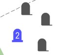
Editing the cluster table |


|
|
For displaying densely located point symbols the algorithm of automatic clustering is implemented. In the Classifier Editor, tools for describing clusters have been added with indicating the view of objects related to each type of cluster, the sizes of cells vertically and horizontally, the semantics code for indicating the current number of objects in the cluster, the view of conventional sign for the cluster, the maximum percentage of the size magnification of the cluster sign, and the maximum number of objects corresponding to the maximum size of the cluster sign. The cluster conventional sign can be programmable, which allows you to select the type of cluster and to change the properties of the sign depending on the number of objects in the cluster (number signature, sign size, brightness, and so on). When grouping in a virtual cluster cell more than one object of a given type, their conventional signs will automatically be replaced by a conventional sign of the cluster, the center of which will have an average coordinate of the objects included in it. When you change the scale, the cluster configuration automatically changes. When you set the property Display the first character in the cluster, the first object in the cluster will be displayed in the position of the cluster character first, and then the cluster icon. In this case, the cluster icon can contain only the number of objects or other complementary elements of the conventional symbol. When drawing an object, various semantics can be taken into account, including links to graphic files, which makes the generalized sign more complex and informative. Maps with clusters customized in the RSC classifier are automatically supported in all desktop and web applications, as well as in applications developed in the GIS ToolKit and GIS Constructor. With a large overload of the map, you can combine signs of close meaning into groups and, if the conditions are met, instead of several signs, display one - generalizing one.
To create a cluster, you must: add a cluster, enter its name, enter the necessary cluster parameters, add objects from the classifier, included in the cluster. The width and height parameters are the horizontal and vertical size of cells for combining characters into a cluster. When entering these sizes, you must take into account that the cells size must be larger the size of the cluster sign at least twice. Limit of the cluster objects number indicates the number of objects combined into a cluster, starting from which the size of the cluster sign no longer increases. Limiting percent of magnifying the size of a cluster sign can be from 100 % to 400 %. If the user for a view of a cluster sign uses a vector sign, he can create a text chain for indicating the number of cluster objects, which is loaded into semantics for displaying the number of signs in a cluster (by default it is semantics 31109). You can change the semantics by pressing the button of a choice or by clicking on the field with the semantics name. View image of the cluster changes when you double-click on the cluster view. When displaying on a map, at large scales, objects are displayed by their own signs, at decreasing the scale instead of several intersecting signs, only a cluster is displayed.
Large scale Small scale
|