Import of vector maps formats SXF, TXF, DIR |


|
|
Format SXF is the format of the exchange and storage of vector maps in the archive. The format is developed in 1992 by specialists of the Topographic Service of the Armed Forces and in 1993 adopted as the main exchange format for digital information on the location in the Armed Forces and a number of Federal Service of the Russian Federation.
Format SXF provides a more effective solution of the following tasks: - archiving of digital topographic and navigation maps and plans of cities; - improve the reliability of storage and transmission reliability of digital maps in various formats and channels of communication; - decrease of sizes for the stored information; - application of various technologies and means for creating digital topographic and navigation maps and plans of cities, with the results to a common format.
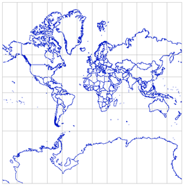
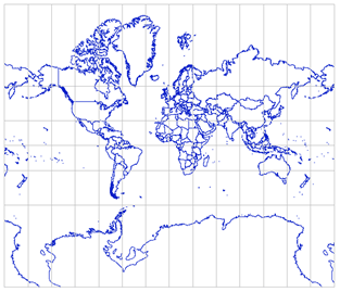
Format SXF may have a binary form or text - in the form of a TXF file. For ease of import of several maps (from two to several thousand) may be applied a text file DIR, containing a list of files SXF and TXF. Under the map can be understood as a separate layer, sheet or a set of adjacent sheets with a common passport. From a single file SXF or TXF a vector map is created, which contains files SIT, SHD, SDA, SSE and SGR. Files SSE and SGR are created only only at presence of semantics and graphic objects. The vector map from separate file SXF (TXF) is created identical to the which it has been saved, without change of parameters of a projection, system of coordinates, units of measure and other properties. To create a vector map, you must select a digital classifier file of the RSC format, containing list of codes of objects and their conventional symbols. If the name of the classifier is written down in file SXF or TXF it at once is displayed in dialogue. In the absence in the classifier of objects codes that are available in the file SXF or TXF, map objects are purple (lines, polygons, point crosses and titles). Which can then be converted by the appointment of a new code and a conventional sign for them, or by changing the classifier onto the one that has a complete set of codes. When you import a map, you can select a list of objects that will be imported, using the Filter button. If the map is imported, which is limited by the frame, then compliance control of framework coordinates on a map and in a map passport is performed. For SXF file the calculation of the checksum and comparison with the value in the passport is performed. All error messages are duplicated in the file LOG, which is located in the folder with the new map. If you find bad areas in the file the processing continues after the bad data site. After importing data the map will automatically open in a new window. From the data sets listed in the DIR file, the multisheet map of MAP format or a set of separate maps of SITX or SIT format united into MPT project can be created. If data sets contain sheets of topographic maps from several zones, then the maps are transformed to the zone of the map (sheet), which is the first in the list. When importing a set of maps sheets of SXF and TXF format, specified by the list in the DIR file, the map sheets can be transfered by longitude in 360 degrees to the left or to the right. It allows to duplicate the columns of sheets in the western and\or eastern hemisphere for expansion of dimensions of work region up to -360/+ 360 degrees. To duplicate sheets, copy the required file with a different name (for example, rename 01-12.sxf to 01-12_west.sxf) and change its nomenclature so that all sheets in the region have a unique designation (for example, rename 01-12 to 01-12_west ). Then, in a text editor, add a line with a new name sxf or txf into the DIR file and press the tab after the file name and enter the direction of transfer (for example, -360 or +360). The recalculation of coordinates and sheet passport will be performed automatically when importing the work region from the DIR file. For example, there are 72 sheets in SXF format from which the world map is formed, occupying in latitude from -180 to +180 degrees (left-side view). Duplicate the outer sheets, update the DIR file and get a new map (right-side view).
DIR world1m.rsc 1.sxf ... 72.sxf 1r.sxf +360 13r.sxf +360 25r.sxf +360 49r.sxf +360 37r.sxf +360 61r.sxf +360 12l.sxf -360 24l.sxf -360 36l.sxf -360 48l.sxf -360 60l.sxf -360 72l.sxf -360
|