Loading the graphic format files in a raster map |


|
|
This version supports the loading files from BMP, PCX, TIFF, GeoTIFF, JPEG, PNG, IMG, GIF, OZF2, OZFX3, KMZ, MrSID (SID, NTF), ECW, JPEG2000 formats. The restrictions imposed (levied) on the initial data: - Loading files from BMP format. The initial file should be decompressed, should be standard Bmp Windows file structure or OS2. Restrictions on the image size and the color table (palette) size are not imposed. - Loading files from PCX format. The initial file should be standard PCX file structure. The files with the compressed image are processed. Restrictions on the image size and the color table (palette) size are not imposed. - Loading files from TIFF format. The initial file should be decompressed, should be standard TIFF format (version 6.0) structure. Algorithm of image compression PackBit is supported. Restrictions on the image storage mode, on the image size and the color table (palette) size are not imposed. - GeoTIFF file should have structure of TIFF format of version 6.0. - IMG, PNG, GIF, OZF2, OZFX3. The mode of converting files of the specified types uses functions of open library for work with the raster and vector data, databases and web-services GDAL/OGR 2.2.0. - MrSID (SID, NTF). Import of MrSID formats has been implemented using the software development kit for images decoding MrSID SDK https://www.extensis.com/support/developers. - ECW, JPEG2000. Import of ECW and JPEG2000 formats is implemented using the software development kit for decoding images ERDASECWJP2 SDK 5.5www.hexagongeospatial.com.
Result of executing the procedure of loading a graphic file is the creation of a file of RSW format and opening the document of a raster map or addition of the raster image into the document of a vector map (depending on conditions of the loading call).
- Loading a pyramid of raster tiles from the KMZ format. A KMZ project contains an archive of a KML file and a set of raster files. The KML file contains a description of the raster data parameters - the names and coordinates of a binding of rasters, and also the priority of their rendering. As a result of importing a pyramid of raster tiles from KMZ, a set of RSW files is formed combined into an MPT project. The optimal displaying the pyramid of tiles is achieved by automatically setting the scale of the RSW rasters' visibility border in accordance with the «Rendering priority" parameter.
The maximum file size for an RSW raster map is 1TB.
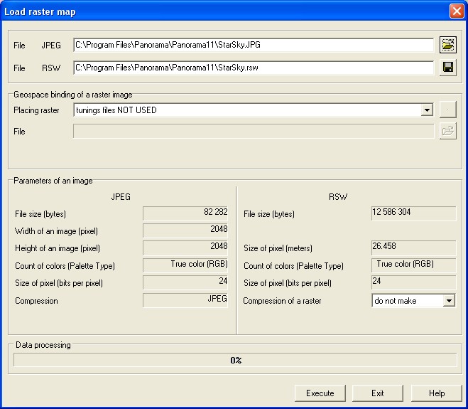
The dialog «Load raster map" description:
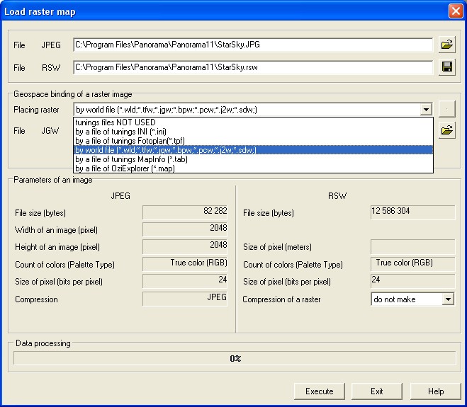
At first it is necessary to choose a initial graphic file name and to specify formed RSW (*.RSW) file name. The change the names of the initial and the target files is carried out by means of «..." buttons. After the file name formation the help information on these files (in the left dialogue part - characteristics of the initial graphic file, and in the right dialog part - characteristics of the created RSW file) is deduced. The edited fields Scale and Resolution characterize a created raster map. If at loading you are at a loss with installation of these values there is an possibility of their change in further. For change the received raster image characteristics (a scale, a resolution, binding, a palette etc.) it is necessary to use Raster List dialog functions. Compression of image field is intended for inclusion the image compression option at loading the raster map. It is recommended to use the given mode at an insufficient empty disk space for a full raster. For unpacking a raster map use Raster optimization mode. Raster adjustment file usage. For automatically position a raster image in the work area, a binding file is used. In the present version the following files of binding may be processed: world file, file of placing .TAB (MapInfo), file of placing .MAP (OziExplorer) file .ZRS (Zulu) and others. For use of a file of raster binding put a tick into field File of parameters with a binding, scale... Also specify its type and name. In this case the raster map will be created with the characteristics listed in a file of adjustments. At loading several graphic files the dialog assumes the following kind:
The option «Add rasters into document after processing all files» influences the moment of adding the rasters into the document. If the option is disabled, addition of ready rasters is carried out in a cycle. If the option is enabled, then addition of ready rasters is performed after import of all files. In both cases addition of rasters into the document is carried out.
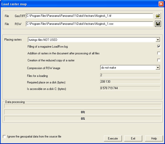
The option « Addition of rasters in the document after processing of all files» influences the moment of addition of rasters into the document. If the option is unused, addition of ready rasters is carried out in a cycle. If the option is used, addition of ready rasters is carried out after import of all files. In both cases addition of rasters into the document is carried out. At loading a raster map of GeoTIFF format the dialog of the following kind becomes active:
For reception of the help information about coordinate system, projection, zone and other parameters of GeoTIFF-file use Parameters button.
|