Geocoding |


|
|
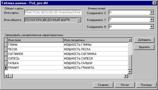
The Geocode mode serves for creation the point objects by coordinates, indicated in the database. The database table must contain fields conforming to coordinates X, Y and H necessarily. If the fields of the table have titles X, Y or H, they will be automatically put in conformity to coordinates. Otherwise the user sets the conformity independently.
Automatically in dialog all fields of the database table will be show and the conformity will be set for those fields which titles are coincide to short name of semantics from the classifier. The name of object will be automatically choosen by a code set in a matrix legend, but it can be changed. The field names of the data table containing X, Y, H object coordinates should be necessarily filled, otherwise geocoding will be not executed. Use the conforming dialog items to change the object name and coordinate fields. It is necessary locate the mouse manipulator on the necessary field or semantic name and to make selection from a list of fields or semantics for modification the conformity the database fields and semantic characteristics. Use Add and Delete buttons for deleting or addition the fields intoa list of the recorded semantic characteristics. If the table field is present at a list,, but it is not set to conformity of a semantic name, then the record into semantics will not be made. If all parameters are filled correctly Further button will be actuated. The pressing of this push button will prolong process of the layers matrix building.
|