Properties of a vector map

Print Top page

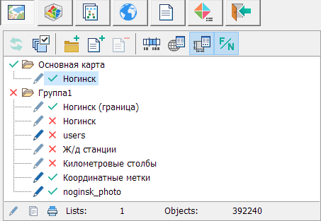
A vector map can be added to the document, removed from the document, you can change its parameters, and also control the display of the vector map as part of the document.


___vect_map_propert_en


Modes for work with vector maps


Update map

Update data on the map.

The mode is not available if automatic updating is installed.

Enable/Disable map visibility

The mode is intended to enable/disable the visibility of one or a group of maps.

Add group

Add group.

Add map

Add a map to an open document.

Close a map

Remove the map from the open document.

Group processing of maps is available.

Scale range

Set the visibility range of the map.

Group processing of maps is available.

Projection parameters

Viewing and editing a map passport.

Map parameters

Displaying properties of the chosen map in the list:

- availability of map editing

- availability of printing the map

- availability of copying map objects

- number of sheets

- number of objects

(!) -discrepancy between the coordinate system of the map and the main document

Map name

Display in the list of the full path to the file/name of the map.


Modes of working with the map tree


Enable/Disable the visibility of maps or groups

It is carried out with a single click of the LMB (left button) in the image display area:

- map visibility is disabled

- map visibility is enabled

Enable/Disable the availability of editing maps or groups

It is carried out with a single click of the LMB in the image display area:

- disabled maps editability

- enabled maps editability

Change the order of maps displaying

It is performed using the dragging mode Drag&Drop.

Group processing of maps is available.

Change the map name

It is performed by long pressing the LMB on the name of the map. This mode is available if the map is available for editing. The name of the card in the list corresponds to the name in the map passport.


Additional modes


Visibility

The mode is intended to select the type of map display:

- fill

- deep

- translucent

- middle

- transparent

- none

Group processing of maps is available.

Highlighting titles

The mode is intended for more accurate drawing of titles on a dark background. All titles are automatically added with a white outline when drawing.


Brightness/Contrast

The mode is intended for customizing a palette of a map, its brightness and contrast.

Over Map

The mode is intended for changing the order of displaying maps. After applying this mode, the current map is displayed over the main map of the document.

Group processing of maps is available.

Automatic update

The mode is intended for automatic set the display of maps in the document when changing their visibility in the map tree

Select all objects

The mode is intended for selecting all objects on the map.

Group processing of maps is available.

Paste selected objects

The mode is intended for copying objects from clipboard to the selected map.

Group processing of maps is available.

Go to

The mode is intended for fast movement on region to the first object of the current map. After use of the given mode the map object is displayed in the center of a visible part of the document (in the center of the screen).

Editing

This mode is used to set the availability of the map for editing.

Print

This mode is used to set the availability of the map output for printing.

Select object

The mode is intended for setting the prohibition of the map objects selection.

Scaling for level

The mode is intended for setting the flag of the scalability of map objects relative to the specified scale. If the menu item is not enabled, scaling is performed relative to the base scale set in the map passport. Active only for maps of situation (created with the operator.rsc classifier).

Database view parameters

The mode is intended for viewing the parameters of the spatial database presentation.

Object contents

The mode is intended for change of contents of displayed map objects.

View Passport

The mode is intended for editing passport data of the map (F8).

Classifier Editor

The mode is intended for editing data of the map classifier.

Place by 2 points

The mode is intended for binding a map in an arbitrary coordinate system to control points with known coordinates.

Change X and Y

The mode is designed to change the X and Y coordinates between themselves. The menu item is available only for maps without a sign in the map passport «Limit the map area with a frame». To cancel the flip of the map, you can perform a «Undo» or re-select the menu item.

Collapse all

The mode is intended for collapsing all nodes in the map tree

Expand all

The mode is intended for expanding all nodes in the map tree

Save as

The mode is intended for saving the map to a file with a different name.

Delete the file

The mode is intended for deleting map files from your computer's hard drive.

Copy the file name

The mode is intended forcopying the full file path to a clipboard.