Create point objects from *.txt file |


|
|
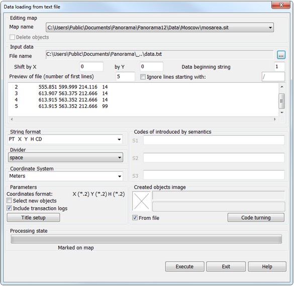
The program works in a mode of dialog. The window of dialog consists of five parts: 1. Path to an edited map in MAP or SIT format (it is possible to choose necessary map from the list of the open maps or to create a new one (at Import from …)). 2. Input data: - Path of access and the name of a source file in which there are data in the text kind, received from geodetic devices (in case of need the user can refuse work with this file and specify other file. For this purpose there is a button which is being to the right of the name of path to a text file). - Fields for input of shift by X and Y, allowing to place created objects on the necessary place. - In the bottom part of group the multistrings window is located used for preview and the analysis of the contents of text file after which the user should be determined with a variant of data processing of an input file. 3. Data for setup of the program for processing an input text file which are kept in an INI-file of the open document: - A choice of a format of a string (allows to set and to choose the Format of a string of an input text file). - A choice of a divider - a symbol by which the data in a string of a text file are divided. - A choice of an image of created objects. 4. The information on a condition of data processing 5. Operating keys (Execute, Exit, Help)
After appearance of the main window the opportunity is given to the user or to take advantage of the settings which have been read from an INI-file of the open document, or to change them at own discretion, having taken new values from the given list as the program allows to process data in various variants of representation.
Processing of source data should be constructed as follows: 1. At Import a text file to create the user map (the button on the right). 2. To choose an input text file (at Updating a map the input file is selected before start of a task), thus contents of a file at once is shown in a multistrings window of dialog. If necessary to set shift of coordinates. 3. Having analysed a structure of a file to choose the Format of a string and the Divider. 4. To choose a name of a target map if it is necessary (by default objects will be created in a background map from which the task has been started). 5. If in an input text file there are codes of objects it is possible to set up them - the button "Codes turning" (if the file of codes set-up is not present, then by default the objects will be put on a map by a system code "Marking of point objects"). If in an initial file there are no codes it is possible to choose image of created objects. For this purpose it is necessary to switch-off the button "From file" and to choose object, having pressed on the image of object or its name. 6. To start the task onto an execution - Execute button.
The condition of process of data processing is displayed in a running line.
|