Downloading JPEG photos with GPS-coordinates onto a map |


|
|
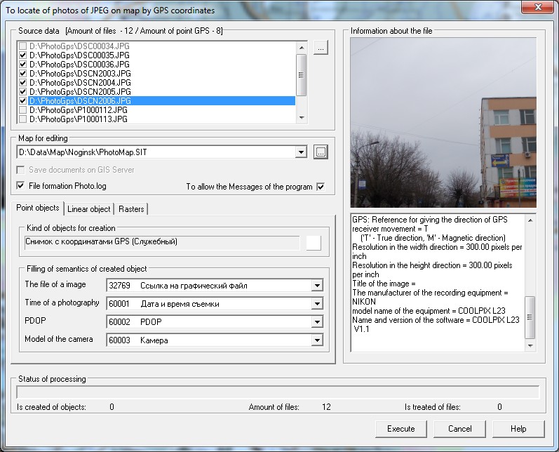
The mode is intended for an automatic binding to a map of photos JPEG containing GPS-coordinates of a survey place in EXIF-tags. This mode processes JPEG photos received by means of devices (cameras, mobile phones), equipped with a module GPS. At an execution of photographing by such devices, into a file of a photo there is added the additional structure corresponding to the EXIF format, into which there are recorded the geographical coordinates of a photographing place, the information about the device, and also various parameters of photographing. As a result of an execution of this mode the dot objects are mapped in which semantics the reference to a file of a photo is written down. For one photo with GPS coordinates on a map one object is created. During the mode execution, photos are copied into the folder \PHOTO\ created in a folder of an edited map.
For a choice of uploaded photos the button «…» is intended in group «Source data». The program analyzes the chosen files for presence of EXIF-tags and GPS-coordinates. If in file JPEG the GPS-coordinates are absent, the line with a name of the given file in the list is unavailable for selection and the file does not participate in the further processing. Choice of a map for drawing objects is made from the drop-down list «Map for editing». The kind of created object is specified in dialog «Create object», caused by the button «…» in group «Kind of objects for creation» of the bookmark «Point objects». In group «Filling of semantics of created object» of the bookmark «Point objects» the choice of filled semantics is carried out. ATTENTION: Semantics «The file of an image» which type should match the «File name of the registered type» is obligatory for filling. The customized semantics and kind of the created object are saved in a parameter file named jpegphoto.xml. The jpegphoto.xml parameter file contains settings for different classifiers of conventional symbols used in edited maps. The parameter file is located in the shared map folder, for example, c:\Users\Public\Documents\Panorama\. Customization of the shared folder of maps is carried out in form the Placement of data, started by means of item of the main program menu “Options\Placement of data”.
Control element «To allow the Messages of the program» influences issuance of messages by the program in the process of downloading files. Control element the «File formation Photo.log» includes recording of transactions into the file Photo.log, which is created in the folder \PHOTO\. Control element «Save documents on GIS Server» is intended for the permission of copying the files of photos to the GIS Server, if the edited map is opened from the GIS Server. Launching the mode «Downloading JPEG photos with GPS-coordinates onto a map» is performed from the dialog «Run Applications».
|