To print map (plan) |


|
|
The map (plan) can be formed for one or several objects of land management (OLM) depending on a variant of doing cadastral works. Besides, the possibility of processing of multicontoured object of land-management is stipulated. Therefore, the program provides the following options for calling the procedure: - for one selected object; - for group of the selected objects. In the first case the button of a mode at first is pressed, and then the polygon object on a map, used for formation of a map (plan), is specified. If the selected object, is one of contours of the multicontoured OLM, the program automatically defines this fact and requests necessity of processing of the multicontoured OLM. At the affirmative answer the multicontoured OLM is processed. At the negative answer one contour is processed only. In the second case on a map necessary OLM at first are marked, and then the button of a mode is pressed. The program automatically defines presence of the selected objects and requests confirmation on processing of several OLM. At the affirmative answer the dialog of the task in a mode of stream processing several OLM will be called. At the negative answer the marking is removed and to the user it is offered to choose object for formation of the report. Management of structure of sections of a map (plan) is made in dialog «MAP (PLAN)».
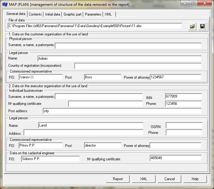
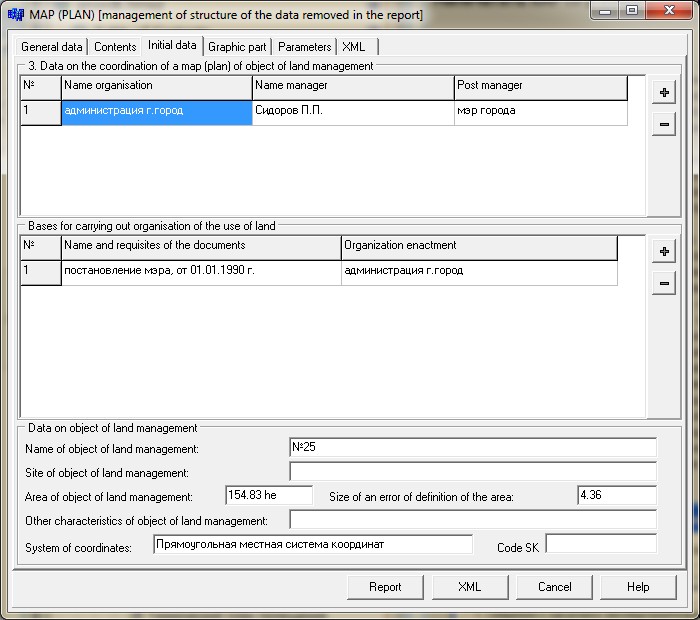
On page «Common data» it is necessary to specify data on the customer organisation of the use of land and data on the executor organisation of the use of land. These data are used at filling the title page. Data on the executor of land-management works can be saved for a reuse in a file of data *.ELW. "Contents" page indicates the structure of the sections included into the report and a folder where templates of a mode are located. Only those sections which will be specified on page "Contents" will be inserted into the report. By default the folder of templates specified in options of the "Geodesy editor» is used. The structure of standard delivery of the GIS Map 2011 includes the necessary for formation of a map (plan) templates. The list of names of sections and templates of documents corresponding to them is described in a file dot.ini. section [MAPPLAN]. One line corresponds to one section of a map (plan). On page «Initial data» are displayed the data placed on the title page «Data on the coordination of a map (plan) of object of land management», in section «Bases for carrying out of organisation of the use of land» and in section «Data on object of land management». All the entered data are saved in semantics of the map object for their reuse.
Structure of the images used at automatic filling the form of a map (plan) is indicated on page «Graphic part». In accordance with Section 25 of «Requirements for drawing up a map (plan) of object of land management» it is allowed to issue the plan of borders of object of land management on a separate sheet for each borders part of object of land management. In this case in structure of a graphic part of a map (plan) of object of land management the surveyed borders scheme of object of land management is shown. Thus, the total of sheets of a graphic part will be equal N +1, where N - number of images of borders parts of object of land management.
Images of the survey scheme and fragments of the plan of borders of object of land management are prepared beforehand. For formation of images for a graphic part it is necessary: - to prepare appearance of the map image; - to choose area for saving the image; - to pick up scale and a format of a printed sheet image; - to save the image into a file. The survey scheme is given in a small scale providing the review of the whole object of land management, and separate fragments of borders plan in the scale providing readability of the location of characteristic points of borders for object of land management. For the specifying several graphic files use buttons On "Parameters" page it is indicated some options used at preparation and automatic filling of the report. After you have specified the common data, contents, and structure of graphic files, click the button "Execute". There is an initialization of the form of a map (plan) and filling it with the necessary data. The result is given as a file of Microsoft Word. As a result of the automated filling there will be created the all sections of a map (plan).
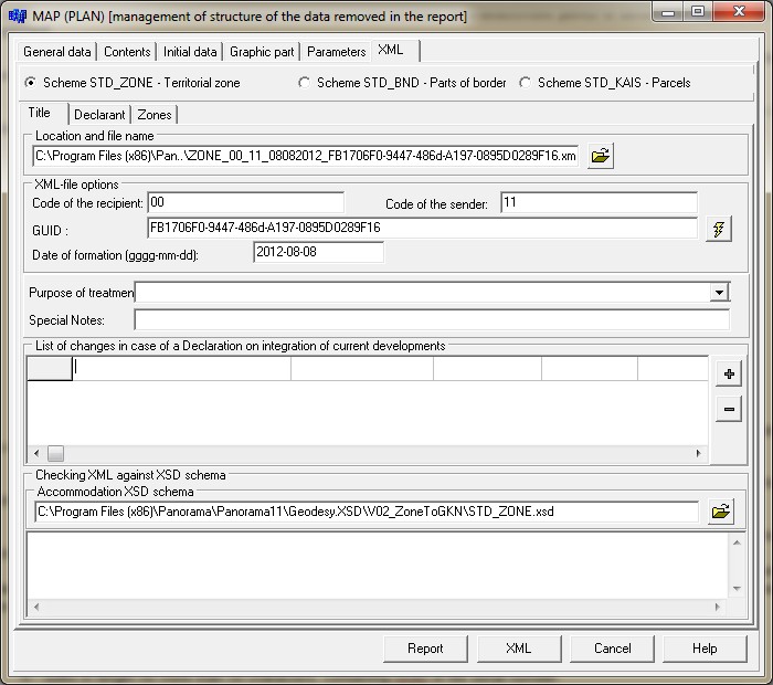
For forming the XML-file of a map (plan) of land management's object the following information is used: - Title of the document; - Data about the declarant; - Data about object of land management; - Data about the point objects characterising rotary points of object of land management.
For forming the XML-file of a map (plan) of land management's object the following information is used: - Title of the document; - Data about the declarant; - Data about object of land management; - Data about the point objects characterising rotary points of object of land management.
Information to form the header of XML-file, specified in page «XML» in the section «Title» is used for forming an unique name of XML file: ZONE_P_O_ddmmgggg_N.xml, (BND_P_O_ddmmgggg_N.xml) where: ZONE - prefix denoting a belonging the information to a file of data exchange between cadastral engineers and cadastral agencies, about territorial zones and zones with special conditions of using the territory;
BND - prefix denoting a belonging the information to a file of data exchange between cadastral engineers and cadastral agencies, about parts of the borders that are passed into the state cadastre of real estate; KAIS - a prefix denoting a belonging of the information to a file of exchanging information between cadastral engineers and bodies of the cadastral registration, about changes of characteristics of land parcels that are transferred to the state real estate cadastre; P - code of the information's recipient; O - code of the information's sender; dd - day, mm - month, gggg - year of formation of a transferred file; N - suffix in length no more than 50 characters, containing GUID or file serial number. GUIID - a global unique identifier that is formed by the program automatically by each pressing the button
Obligatory element for filling in the section «Title» is the field «Purpose of treatment».
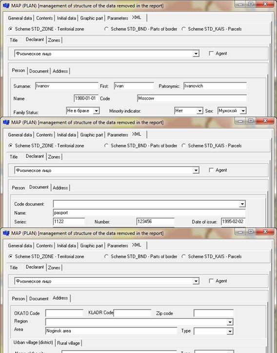
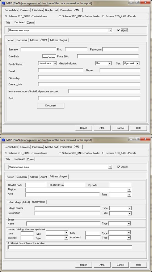
It is offered to fill this field from the list. The list is formed from a directory «Classifier of accounting and registration actions by treatments» (dAction.xsd). If there is need to write down the element «List of changes» in case of the declaration on taking into account of current changes it is necessary to fill attribute «Codes by the classifier of characteristics of current changes» (directory dCurrentChanges.xsd). In section «Declarant» it is required to choose the declarant from the list and to specify: For the declarant «Person» obligatory requisites for filling - a surname, a name, and also sections «Document» and «Address». For the declarant «Organization» an obligatory requisite - «Name of organisation», and also sections «Document» and «Address». The optional requisite code OPF (Organizational-legal form) is selected from the directory dOPF.xsd. Data about the document include the description of the document by group of the structured parametres and a set of graphic files - document images. Mandatory attributes describing the document, are: a code, a name, a series, number and date of registration of the document. The document code is selected from are directory dAllDocuments.xsd. For the declarant «Authority» or «a Foreign legal person» the obligatory requisites for filling - «The name of authority», a code of types of authorities. The code of types of authorities or foreign person is selected from the directory dGovernance_Code.xsd. If data on object of land management (a territorial zone or territory border) are provided on behalf of the declarant by its authorised representative, in dialog it is necessary to set the flag «Agent». This activates two additional bookmarks «Agent» and «Address of gent». On page «Agent» obligatory requisites for filling are: a surname, a name, and also data about the document on the basis of which the agent operates. To do this, use the button «Document». Information about the document - the basis is entered in separate dialog. Mandatory details in the document description are «Code of document», «Number of document ». At filling the information about the address an obligatory requisite is «Region code» is selected from the directory dRegionsRF.xsd. The attributes characterising the address of object of land management are used in a complex at report and XML-document filling. For the address attributes, at which the value type is provided, input of semantics should be done by pairs (for example: the name and type of city, street and type of street). To write down the address attribute into file XML, it is necessary to enter value of an address element (district, town, street, house, building, structure or apartment) and to specify the type. Types without values are not recorded into files.
Input of data about code OKATO or code KLADR is provided in the form of simple input of the symbols characterising the corresponding code of value of the Russian classifier. Maintaining a hierarchical database of address-territorial formations in the current version of the program is not provided. A different describing a location of the object of cadastral works is used to enter information about the name of non-profit formation of citizens or other non-formal description of the object's location.
Dialog provides data input for formation of XML-documents according to the scheme STD_ZONE.xsd - «Territorial zones and zones with special conditions of using the territories», under scheme STD_BND - «Data about parts of the borders, transferred into the state cadastre of real estate» and under scheme STD_KAIS - "Data on changes of characteristics of the ground areas considered in the state cadastre of real estate».
Choice of XML-scheme is carried out in the top part of dialog:
Choice «Scheme STD_ZONE - Territorial zones …» activates the «Zones» bookmark. Choice «Scheme STD_BND - Parts of borders …» activates the «Bounds» bookmark.
At a choice of «Scheme STD_KAIS - Parcels» the bookmark «Objects» is activated.
At file structure XML there are present mandatory and optional for filling the requisites and attributes. During the forming a body of XML file the program carries out control of presence of all mandatory elements. At their absence diagnostic messages are given. The user can continue building a XML file, but this file is wrong and will not be accepted for registration in the cadastre. Necessarily the folder should be specified for placing the created file XML. In «Zone» section obligatory requisites for filling are: «Cadastral district», «Zone type by classifier», «Zone kind by classifier», «Number», and also section "Document base". «Zone type» and «Zone kind» are selected from directories dRealty.xsd and dZone.xsd, a part of the XSD-scheme. Recommended types of zones: «Territorial zone» or «Zone with special conditions of using territories». For «Territorial zone» an obligatory element for filling «Type of permitted use», and in this element an obligatory requisite for filling «Permitted use (nomenclature)» directory dUtilizations.xsd. For «Zones with special conditions of using the territories» the mandatory element for filling «Content of limitations». In «Bounds» section the mandatory elements for filling «Bound type», and also section "Document base". In the element «Boundaries» an obligatory requisite for filling - «Location». For each of border's types the mandatory requisite for filling - the Name (contiguous foreign state, territory,municipality, town). For recording into xml-document the attribute «Geopoint_Opred» - method of determining coordinates of a characteristic point, it is necessary for each rotary point to write down the special semantics «Mode of determining a characteristic point - code 1225». In section «Application object» the information about the object selected on a map is filled. For parcels the category of the lands is filled by the directory «Land categories» (dCategories.xsd). For objects of real estate the object kind is specified by the classifier «Types of objects of real estate» (dRealty.xsd). These attributes are mandatory for filling. In an element «Description of the location» it is necessary to fill the data about the old and new address. Data about addresses are entered in dialog that is activated by pressing the button To write down lists of the presented documents, it is necessary to press the button When you exit the dialog the entered data automatically are saved in XML-file, which name is specified on the page «XML» - «Title». Information about the name of the file is saved into semantics «FILE XML» of a map object - object of land management. At repeated opening of dialogue «MAP (PLAN)» for earlier used object, information from the XML-file will be automatically retrieved and displayed in corresponding elements of dialogue.
|