To print the LAND-PLAN |


|
|
The land-plan can be generated for one or several ground areas depending on a variant of doing cadastral works. Therefore in the program the following variants of a call of procedure are stipulated: - for group of the marked objects; - for one selected object. In the first case on a map the necessary ground areas are marked and the button of a mode is pressed. In the second case at first the button of a mode is pressed, and then the polygon object - the ground area used for formation of the land-plan is specified. ATTENTION: The program is rigidly set up onto use of the certain keys of objects and semantics. Before use of the procedures which are a part of the «LAND-PLAN» complex it is necessary to set up the digital classifier of a map. Into standard delivery of the GIS Map 2011 the classifier map500.rsc is included, in which all necessary settings are executed (Requirement to the classifier used at preparation of the land-plan ) Management of structure of sections of the land-plan and by the contents of the title page in «LAND-PLAN» dialogue is made.
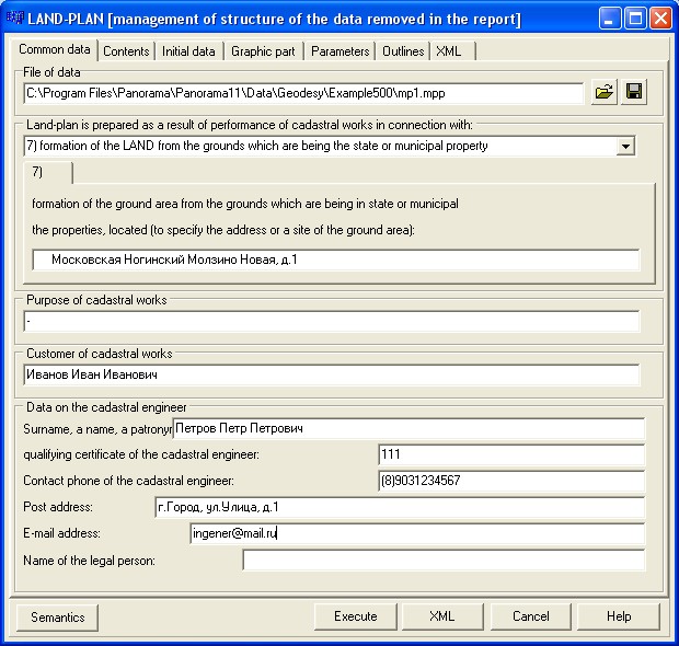
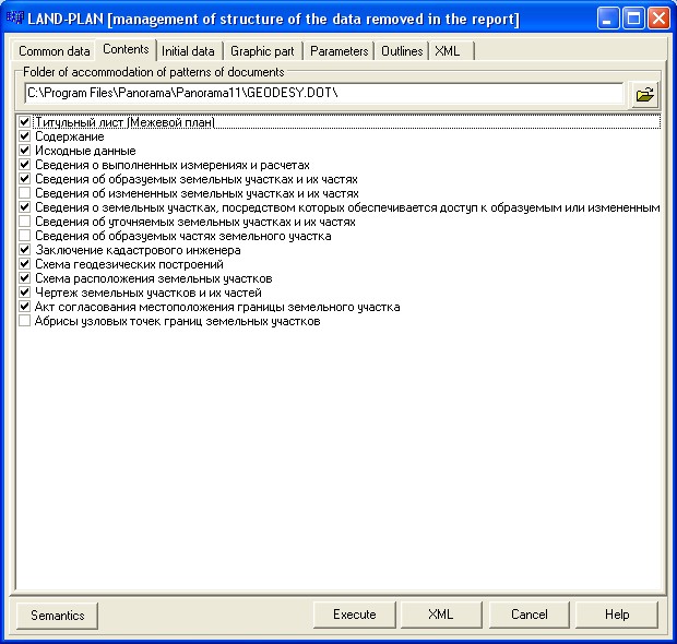
On «Common data» page it is necessary to specify: - in what connection the land-plan is prepared; - the purpose of cadastral works; - data on the cadastral engineer. These data are used at filling the title page. The entered information can be saved for a reuse into a file of data *.MPP. On "Contents" page there are specified the structure of the sections included into the land-plan and a folder in which patterns of the surveying plan are placed.
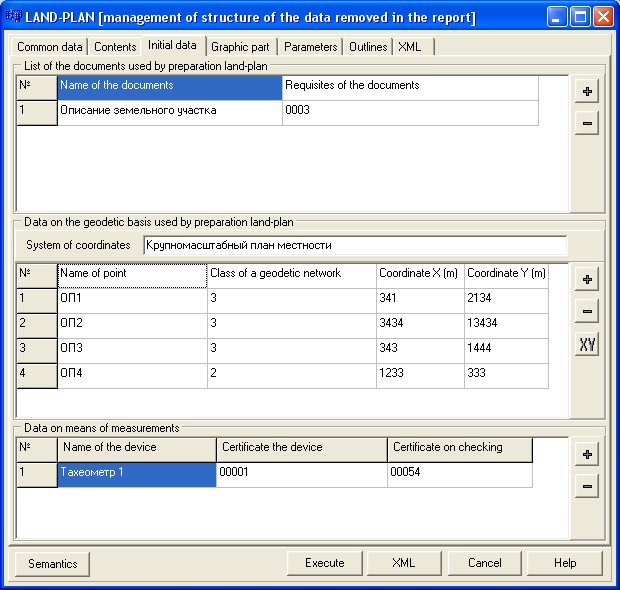
The folder of patterns specified in options of "Geodesy editor» is used by default. The structure of standard delivery of the GIS Map 2011 includes patterns necessary for formation of the land-plan. The list of names of sections and corresponding to them of patterns of documents is described in a file dot.ini. section [MEJPLAN]. One line corresponds to one section of the land-plan. Only those sections which will be specified on "Contents" page will be inserted into the land-plan. On «Initial data» page the data placed into section «Initial data» of land-plan are displayed.
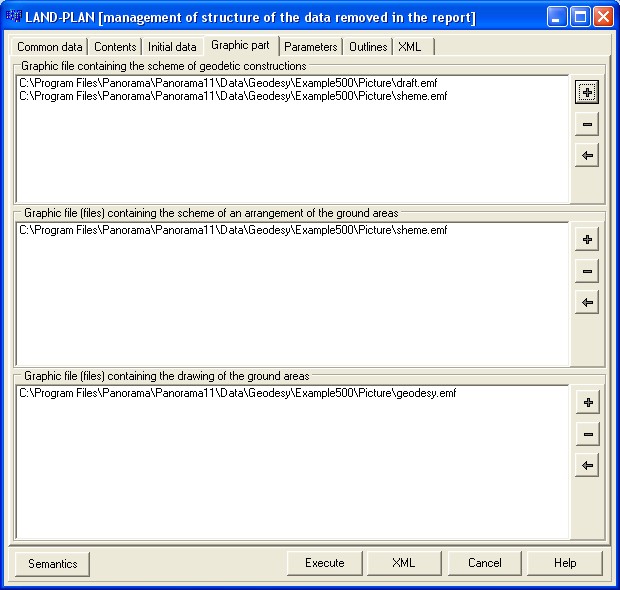
In groups «List the documents used by preparation of land-plan» and «Data on the geodetic basis used by preparation of land-plan» the corresponding information is displayed, which is stored in the semantics of map objects - the ground areas. Input of data for display in these elements of dialogue is made in dialogue Editing of semantics of object the GROUND AREA . Editing of REGISTRATION DATA of object (semantics) . However the opportunity to make change in the specified lists of data is given to the user. The updated lists are used at formation of the report, but not saved into semantics of objects. In «Data on means of measurements» group the list of means of measurements and their properties are shown. The entered information is saved in a file of data *.MPP, for a reuse. On «Graphic part» page is specified the structure of the images used at automatic filling of the form of the land-plan.
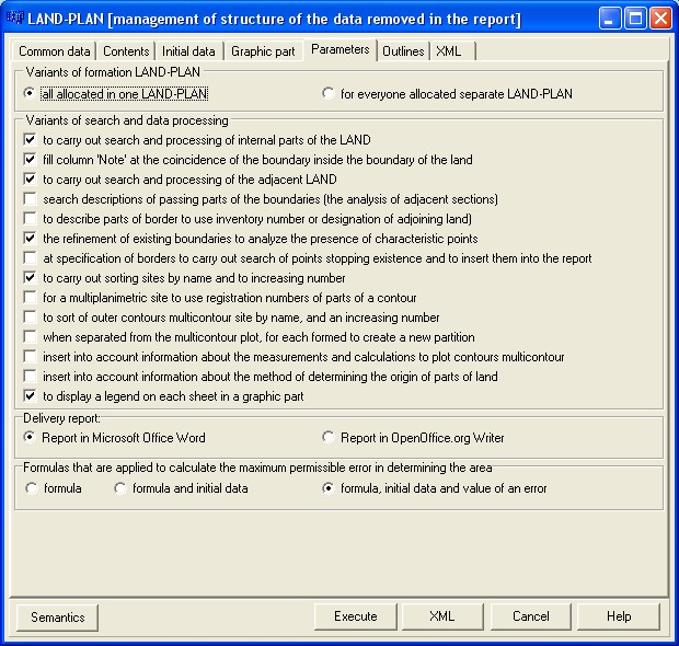
It is necessary for you to fill all positions: - Graphic file containing the scheme of geodetic constructions; - Graphic file (files) containing the scheme of an arrangement of the ground areas; - Graphic file (files) containing the drawing of the ground areas. For the specifying of several graphic files for the scheme or the drawing use buttons: The land-plan can be generated for one or several ground areas depending on a variant of doing cadastral works. Procedure « Formation of the land-plan » provides support of formation of reports by one of four variants: - One land-plan for the object chosen on a map. - One land-plan for the multiplanimetric ground area. - One land-plan for group of the selected ground areas. - Some land-plans for group of the selected ground areas. On "Parameters" page it is specified: - variant of formation of the land-plan; - variants of search and data processing; - package of office programs (the chosen package of office programs should be installed on a working computer beforehand); - variant of formation of the formula, used to calculation of a maximum permissible error of definition of the area.
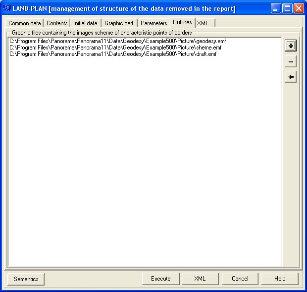
Section «Outlines of nodal points of borders of the ground areas» is included into structure of the land-plan in case the cadastral works were carried out with a view of formation of the ground areas or specification of borders location of the ground areas at observance of following conditions: - if borders of the ground areas contain nodal points (the characteristic points, being the common points for borders of three and more ground areas); - at presence in radius of 40 meters from such nodal point not less than three long-term, legibly identifiable objects of district (elements of buildings, structures, constructions, support of transmission lines, etc.). On an outline specify the values of the measured distances up to the specified objects of district. Formation of outlines of rotary points dialogue is intended for preparation of outlines of characteristic points of borders of the ground area. The button of a mode is located in group «Formation of reports». On "Outlines" page the list of the graphic files containing outlines of rotary points is specified.
On "Outlines" page by using buttons After «Common data», «Contents», «Graphic part» and «Outlines» are installed, press "Execute" button. There is an initialization of the form of the land-plan and filling its by necessary data. The result is made in the form of file Microsoft Word or OpenOffice.org Writer. All sections of the land-plan, except for applications, are created as a result of the automated filling. You should add applications independently.
|