Parameters of the scheme of object |


|
|
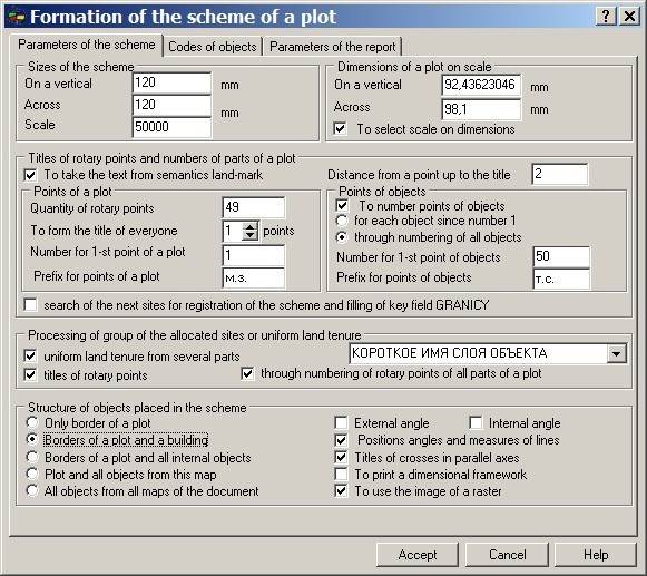
Parameters of the scheme of object regulate the sizes of the scheme placed into the report, its scale and object structure. Also on this page the necessity of creation and the order of location on the scheme of separate elements of registration are specified.
Sizes of the scheme define the sizes in millimeters of the created scheme of object. As the created scheme is put into the document of the certain format this parameter is a determinative parameter at a placing of the scheme into the report. On a sheet of А4 formatvertically oriented (a book kind), at margins in 2 sm from each side, it is possible to place the scheme by the size 17 on 26 sm (170 х 260 mm). In that case if the place, allocated for the scheme in a pattern of the document, less or equally in the sizes to the created scheme the figure, placed into the report, will correspond to its own scale. Otherwise MS Word will reduce the sizes of the scheme so that it was put into the area allocated for it. If the place allocated for figure in the report allows to create larger in the sizes the scheme it is necessary to specify the new sizes of the scheme (for example, for a sheet of А3 format). Dimensions of a plot on scale allow the user to estimate the true sizes of object for the chosen scale. In other words it is possible to see whether the object is located or is not into the dimensions allocated to it. If the object is not located by the sizes into the created scheme, or, on the contrary, is very small, it is necessary to make changes or to the sizes of the scheme, or to select the scale so that the object completely was located into the allocated area. An element "T o select scale on dimensions" automatically will select the nearest suitable scale. Titles of rotary points of object (plot) can be formed on the basis of numbers of the corresponding points of the metrics or by the name of corresponding point objects (land-marks) on the basis of which the polygon object (plot) has been created. In the event that titles of rotary points are formed by numbers of points of the metrics, the user can specify the initial number for forming titles of points. This number will be added to number of a point of the metrics. Besides, it is possible to specify a prefix of created titles. For example, if the prefix is equal « м.з. », and number of a point 10 and numbering begins since 15 the following title will be created "м.з.25.". Similarly numberings of rotary points of a plot the numbering of angular points of internal objects (constructions) can be executed, for this purpose it is necessary to set a flag «To number points of objects». If the flag «for each object since number 1» is set the program will generate titles of angular points of each internal object separately, since number 1. If the given flag is not set, numbering of points of objects will be a through one with increase in number of each following point. By default numbering of the first object begins from number, following after number of last rotary point of a plot, further there is an iterative increase in numbers of angular points. For example, if number of last point of a site = 8, number of the first point of the first internal object = 9, at amount of points of the first object = 4, the number of the first point of the second object = 13. In that case if titles of rotary points are formed by name of land-marks (it is necessary to set a corresponding tag), titles will be formed on the basis of semantics «own name» of a corresponding land-mark. If the land-mark is absent, or it does not have semantics the program will use the number of a point of the metrics and a prefix. If on a map some objects are selected the program can generate the land-management documentation in two directions. The first, to process each object separately (stream processing), second, to consider all objects as parts of one site - uniform land tenure. For the indication to the program of a variant of processing of the selected objects use a flag: uniform land tenure from several parts . At processing uniform land tenure it is possible to specify in addition to the program the necessity of through numbering of points of all parts of a plot. The name of a part of a plot is chosen from the corresponding semantics. The most convenient for these purposes is semantics NAME. At processing group of objects it is possible to specify to the program the necessity of formation of titles of rotary points. It is necessary to unload the scheme from a plenty of titles. Names of rotary points all the same will be present in the report. Structure of objects placed on a map is defined by the chosen structure of initial data and by a set of the installed tags of elements of registration. The external angle element definesto put or to not put onto the scheme of the title of external angles of object (plot). The internal angle element definesto put or to not put onto the scheme of the title of internal angles of object (plot). The direction on neighbours elementdefinesto put or to not put onto the scheme a vector object (more often an arrow), specifying onto an arrangement of the next object. The element: title of length of line defines to put or to not put onto the scheme of the title of lengths of lines between rotary points of object (plot). If on the scheme it is necessary for the title of coordinates of crosses to arrange in parallel to the corresponding axes, use a flag: Title of crosses in parallel axes . At installation of a flag: to print a dimensional framework , the framework limiting a zone of output of the information is located into the report. If necessary to place into the report the values of internal or external angles of objects, specify a corresponding flag. Angles are made out by arches and titles.
|