Creation of titles of geodetic coordinates of rotary points of object |


|
|
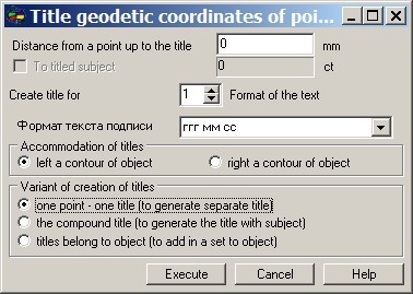
In dialogue it is necessary to specify some parameters of creation of titles: - distance from a point of object up to the title in millimeters; - a format of the text of the title (kind of representation of degree sizes of geodetic coordinates); - to specify accommodation of titles (at the left or to the right of a contour of the chosen object); - to choose variant of creation of titles, etc.
At presence of subobjects at the object chosen for signing, it is possible to execute formation of titles of geodetic coordinates of rotary points of all subobjects. For this purpose it is necessary to set into true an element of dialogue «To title subject».
|