Forming titles of coordinates of points |


|
|
As a result of an execution of operation there is a creation of the title of coordinates of each rotary (angular) point of the object specified on a map.
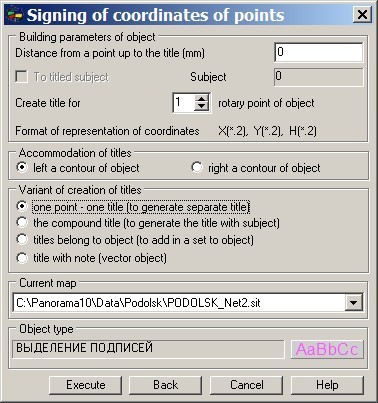
Building parameters of object group is intended for input of distance from a point of object up to the title, specified in millimeters. At presence of subobjects in the object chosen for signing, it is possible to execute formation of titles of rotary points of all subobjects. For this purpose it is necessary to install into true the element of dialog «To sign subjects». The text of the title is formed by the coordinates of a corresponding rotary point of the chosen object. The number of signs after a decimal point is defined in parameters of the Geodesy editor. Group Accommodation of titles will allow to choose at the left or to the right of a contour of the chosen object the coordinates of points will be put. By means of group a variant of creation of titles it is possible to choose a variant of the created title. Probably three variants of creation of titles. The first - one point - one title. As a result of operation for each rotary point the one object of a map is created - the title. The second - the compound title. As a result of operation the compound title (the title with subjects) is formed. For the first rotary point the object - title is created, for all other points the titles are created as subobjects of the first created title. As a result on a map the titles are visually placed the same as and at creation of separate titles, but are selected as one object. The third - titles belong to object. As a result of operation the separate titles for each rotary point of object are created, but at them the special semantics is formed specifying a belonging to a set. The main object of a set is the map object for which signing of rotary points is made. The titles, created so, it is possible to choose as separate objects of a map, or to operate with them by means of modes of the basic editor - «a set of objects». Use of the given opportunity allows to trace "history" of objects. For example, having selected group of objects by one pressing of the button (the titles belonging a site), it it is possible to carry out group operations (moving, rotation, deleting, etc.). Current map group is intended for a choice of an electronic map on which objects will be created. The edited map can be chosen from the list of the open maps. Object type group is intended for a choice of a type of the created title from the classifier of an edited map for created object. Back button is intended for a cancelling of operation on creation of objects on an edited map.
|