Import of data from format GML(XML), GeoJSON |


|
|
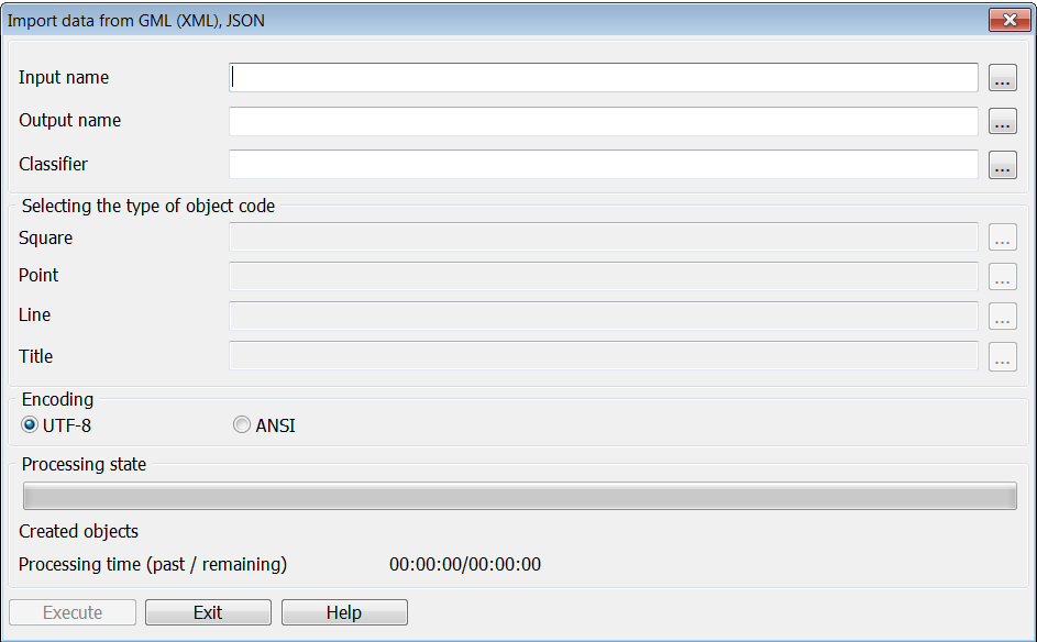
The task is intended for import of vector spatial data of formats GML (XML) or GeoJSON. For the task execution it is necessary to choose an input file, to fill out a name of a created vector map and digital classifier RSC (RSCZ).
An object record in GML format can look like:
<gml:featureMember> <bsd:Street gml:id="N-37-002.16126237"> <bsd:StreetCode>44200000</bsd:StreetCode> <bsd:WidthRange>МЕНЕЕ 20М</bsd:WidthRange> <bsd:Height>123.5</bsd:Height> <bsd:Category>ПРОЧИЕ УЛИЦЫ</bsd:Category> <gml:LineString srsName="urn:ogc:def:crs:EPSG:4326"><gml:posList srsDimension="2" count="3">109.677853573416.7314060146109.677754264116.7308147892109.677358836716.7300170164</gml:posList> </gml:LineString> </bsd:Street> </gml:featureMember>
Coordinates of objects are formed according to GML specification. Semantics of objects in GML file is selected from the nodes having a prefix of the applied scheme (for example, bsd:). The node name is searched among the semantics keys in the map classifier (for example, StreetCode, WidthRange, Height and others). Into object those attributes (semantics) will be added the keys of which have coincided with a name of node without a prefix. If in the description of the object metrics there is a node gml:name then it is considered that it is the signature text. For example:
<gml:featureMember> <topo100t:LAYER17 gml:id="_0.N-37-016.16803349"> <topo100t:SEM214>1.4 мм</topo100t:SEM214> <gml:LineString srsName="urn:ogc:def:crs:EPSG:4326"> <gml:name>Битца</gml:name> <gml:posList srsDimension="2" count="2">55.504131280 37.709670012 55.500860199 37.716630692 </gml:posList></gml:LineString> </topo100t:LAYER17> </gml:featureMember>
The code of object (conventional symbol) can be assigned in the dialog for all objects of one localisation (polygon, linear, point, title) or be selected from a node the key of which coincides with a key of the service semantics with the code 32800.
An object record in GeoJSON format can look like:
{"type":"Feature", "geometry": {"type":"Polygon", "coordinates": [ [ [38.386942060,55.963682015],[38.386787317,55.963321806],[38.386472310,55.962960711], [38.386804368,55.962243924],[38.387448577,55.962067848],[38.388243122,55.962521401], [38.388231937,55.963240048],[38.387905569,55.963597603],[38.386942060,55.963682015]] ] }, "properties":{ "id":"Ногинский район.18148", "perimeter": 469.672, "area": 14673.403, "code":31120000,"layer":"ГИДРОГРАФИЯ", "layerid":"Hydrography", "schema":"_200t05g", "name":"ОЗЕРА ПОСТОЯННЫЕ ", "Shoreline":"ПОСТОЯННЫЙ", "AbsoluteHeight":"149,5"} },
Coordinates of objects are formed in accordance with the GeoJSON specification. The semantics of the objects are selected in the properties section. The field name is searched among the keys of semantics in the map classifier (for example, Shoreline, AbsoluteHeight and others). In object those attributes (semantics) will be added, the keys of which have coincided with a field name. The field with the name "key" can contain a key of object from classifier RSC, the field with a name "code" can contain an object code. If there is a field with a name "title", then it is processed as the title text.
Features of formation of digital topographic maps in GML format are given in the document "Formats and specifications of data. Specification of GML for DTM" (https://gistoolkit.ru/download/doc/specgml4topo.pdf).
|