Map comparing |


|
|
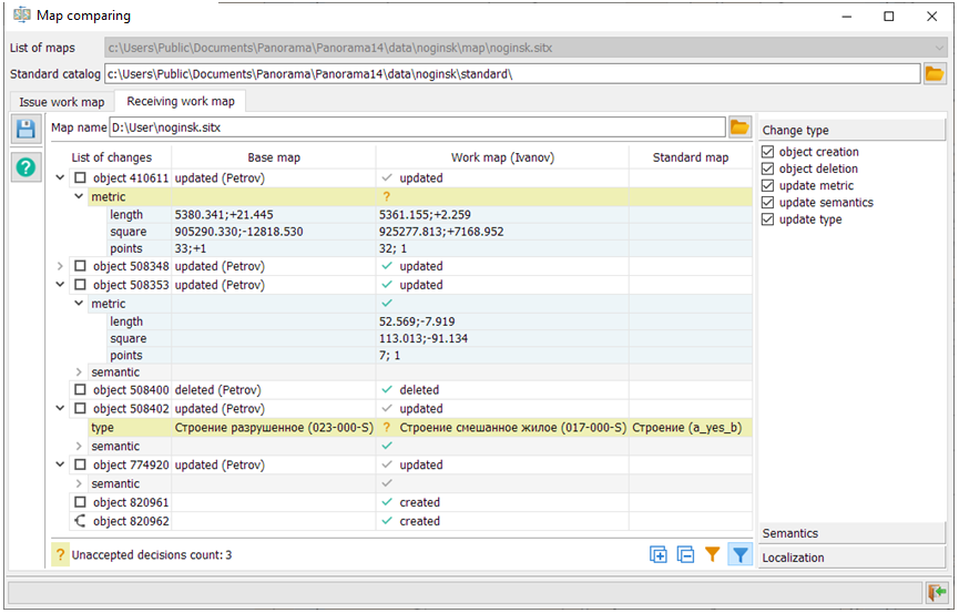
The task provides the issuance and receiving of a work map (a fragment of a common base map) for the same territory for several operators. This possibility allows to carry out parallel tasks on updating of the map data. For example, one operator can specify the coordinates of cadastral plots, the second one can update the power grid facilities, the third one can update the gas facilities. When receiving data, a consistency check is made between the changed work map data and the current state of the base map. At the first stage of the task, a fragment of a digital map is selected and the standard of the given fragment is memorized. Upon completion of map update a receiving a map from the operator is carried out. At this stage, the table of changes of a working map in comparison with the standard is formed. The table contains changes in the composition of objects, metrics and semantics of objects. To fill in the table, the analysis of changes by the operator of the work map and the analysis of changes in the corresponding fragment of the base map by other operators from the moment the work map was issued are carried out. The two sets of map changes are compared against each other for inconsistencies. If there are no conflicts, the lines of the change table contain green checkmarks and the corresponding changes can be accepted automatically. If there are contradictions, the lines contain question marks that require the intervention of the administrator who accepts the updated work map. The administrator must decide whether to accept or reject the current change. If the change is rejected, a red cross will appear in the selected cell of the table; otherwise, a green checkmark will appear. The status bar contains the number of decisions that were not made. Before accepting changes of the work map, it is recommended to resolve all contradictions. The task is called from the main menu of the program: Tools - Run Applications - Check and correction of data - Map comparing.
Task stages
The path to the standards catalog is formed automatically relative to the location of the main map: ..\standard\.
|