Topological data control |


|
|
Types of checking the group "Topology" are divided into two subgroups: - types of check, which as well as and structural control, check of the passport of a map sheet, metrics control, control of semantics, it is enough to execute once for all objects of sheet; - types of check which for one sheet should be executed repeatedly with the partition of controllable objects into separate independent groups.
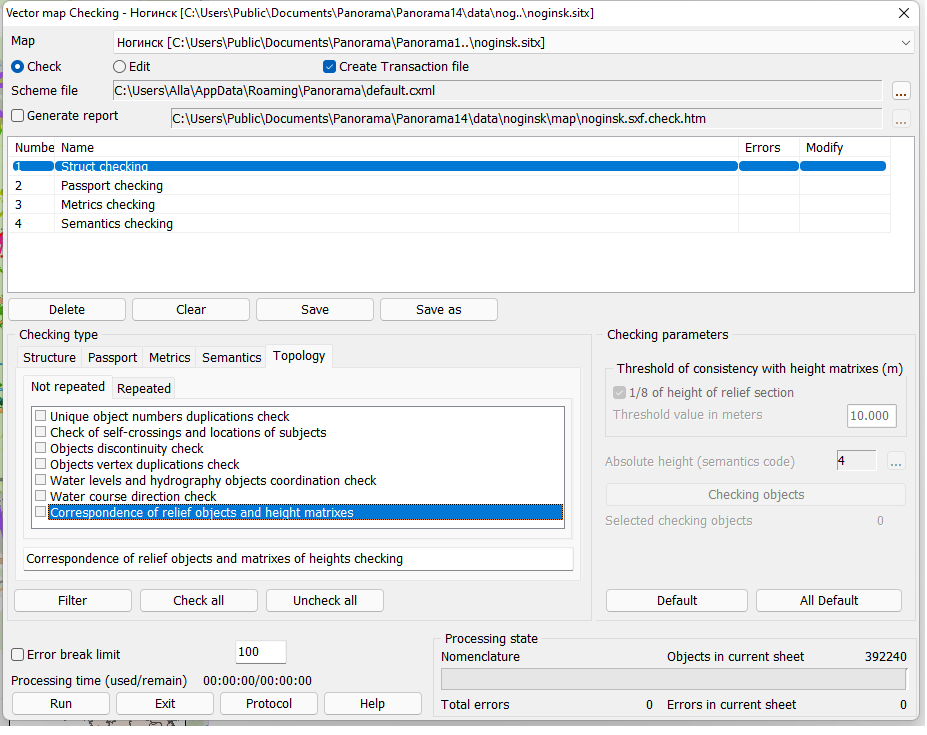
Topological checking of the information includes the following not repeated types of control: - Self-crossing checking. Check of the metrics of object on crossing of its consecutive pieces with each other. - Subjects reentrant check. Checking the location of sub-objects within the object. - Duplication of unique objects numbers. Checking the presence on a sheet of objects with the same numbers. If such objects are present, the repeating numbers are corrected in a mode of editing. - Objects vertex duplications check. A check for full or partial matching of the metric description of objects is carried out. This mode supervises coincidence of the one-type objects. For this type of control additionally it is possible to set the option Checking with the matching semantics. In this mode the presence on a map of double and more objects, that are not seen visually, is checked. It is possible to find concerning objects (cut). - Object discontinuity check. At performance of this control the presence on a map of the one-type objects touching each other is checked. For this type of check additionally it is possible to set the option Checking with the matching semantics. The error is fixed, if the one-type objects have at least one common point. These errors often arise after converting the data, as many packages have restriction on length of object and cut them into pieces. - Check and coordination of water levels and objects of hydrography. - Water course direction check. The direction of watercourse objects is considered correct if according to a vector map the value of absolute height in a end point of linear object is less than value of absolute height in a beginning point. For this type of control additionally it is possible to set the option Allow equal heights at beginning and end of object. Check is carried out for the linear objects, the length of which is not less than the specified in the parameter the Minimum length of testing object (mm on map). - Control of correspondence of relief objects and height matrixes. In the presence of a matrix of heights for each point of object with 3D metric a check of correspondence of value of the third coordinate of a point of the metrics and value of height in a matrix is carried out. If the third coordinate in the object metric is absent, then the correspondence of the value "Absolute height" of the object semantics and value of height in a matrix for each point of object is checked.
Topological control of the information includes the following repeated types of checking: - Nodes existence check. First with help of the filter the objects which should have nodes are set. Then with help of other filter the objects are set, with which objects of the first group should have the common points. After that the presence of node points is checked. In an editing mode the nodal points are placed, if necessary. At performance of checking the presence of nodal points the coincidence of the beginning or the end of one object and an arbitrary point of another is checked. If such point is not present, but there is other point lying in a range, defined by the field Threshold for error detection, then in the mode of Check the data the error is diagnosed, and in the mode of Edit the central points and points of intersection of objects are automatically created. After performance of this control in the mode of Edit, it is necessary to see visually all created nodal points and to remove, if necessary, the remaining ends of objects.
In this mode it is possible to process the following combinations of objects forming nodal points: - linear roads - towns, roads, quarters and streets; - hydrography linear - linear and polygonal hydrography; - horizontals - precipices, scours and crags; - dry riverbeds - dry channels of the rivers.
This list is not full and depending on scale of a controllable map and requirements to it, the list can change and be supplemented.
- Intercrossing objects with each other. At performance of this control a presence in one map point of several types of objects, inadmissible in one point (wood and lake and, etc.) is checked.
In this mode it is possible to process the following combinations of objects:
- vegetation polygonal - hydrography polygonal; - hydrography polygonal - soil polygonal; - hydrography polygonal - roads linear and polygonal; - hydrography polygonal - horizontals; - hydrography polygonal - hydrography linear and polygonal.
This list is not full and depending on scale of a controllable map and requirements to it, the list can change and be supplemented.
- Mismatch of objects. At performance of this control a presence on a map of groups of objects which metric information is not coordinated is checked. If the object of the first group has a point which is lying in a threshold of error detection from points of object of corresponding group and not coinciding with it, the error is diagnosed. In this mode the exact copy of an object part of one group and object of other group is checked.
In this mode it is possible to process the following groups of objects: - roads linear - vegetation polygonal; - roads linear - settlements polygonal; - hydrography linear - vegetation polygonal; - quarters polygonal - settlements polygonal.
This list is not full and depending on scale of a controllable map and requirements to it, the list can change and be supplemented.
All repeated types of check are added into the control scheme consistently. For each type of check it is necessary: - to customize structure of processed pairs of objects kinds; - to set parameters; - enter the conventional name of pair of objects kinds, for example: «Horizontals - Hydrography (polygonal)», «Horizontals - Precipices»; - press button "Append" in group of repeated types of control. |