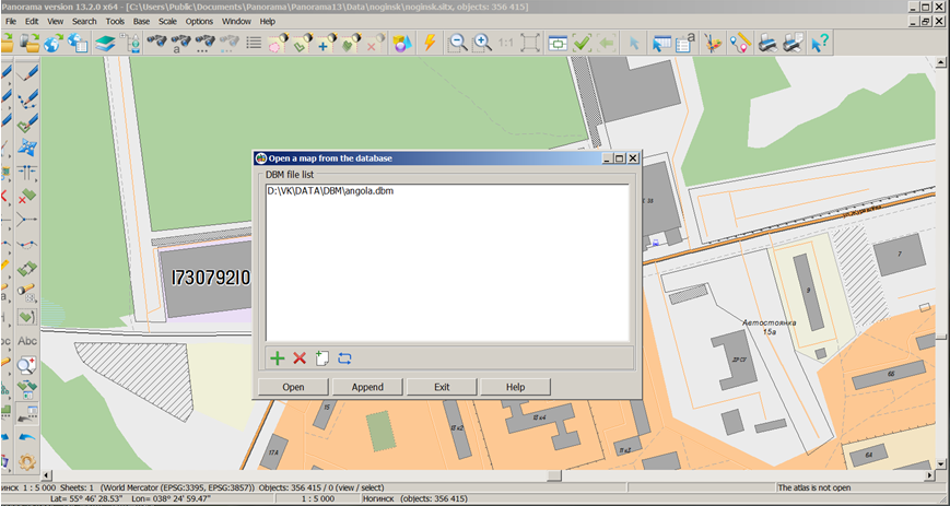
Open a map from the database |


|
|
The task is intended to provide access to the contents of spatial databases (DB). For link with a database the file of DBM format is used, which contains a description of parameters of a digital vector map in the view of which the data from database of spatial data (table, view, or result of SQL-query) will be displayed. For storage, creation and editing of DBM files the XML-document was created called DBMLIST.XML, which is located in the shared folder of files of parametres of system's tasks ("c:\Users\Public\Documents\Panorama\") is created. To open a map described in DBM, use the Map DBM command (File menu) or press the Map DBM button on the toolbar. Tools for work with dbmlist.xml are presented in the dialog "Open a map from the database":
Dialog view:
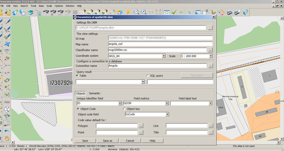
DBM files can be added into the list, deleted, created and edited, using the buttons on the toolbar. The Open and Add buttons are intended for opening on the screen of a map which is described in the dbm-file chosen from the list, or for its addition to the current one. The dialog provides multiple files selection. To create and edit a DBM file, use the "Parameters of spatial DB view" dialog box:
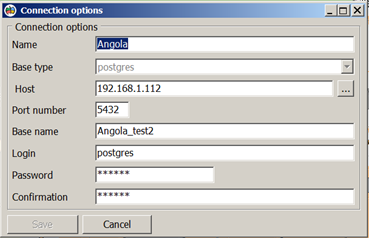
At creation of a new file it is necessary to specify a full path to the folder with name DBM, the map identifier is formed automatically. The map name, base scale of displaying conventional symbols and system of coordinates are entered by the user and are obligatory for filling. The map classifier is selected by the user from existing classifiers and stored in the folder of shared classifiers or in the folder where the edited DMB file is located. When you open the classifier the keys and codes of objects are checked. Unconfirmed codes are displayed in red. When you select a connection name or edit, an attempt is made to open the specified database, then the presence of the specified tables and fields is checked. If no tables or fields are found, the corresponding names are displayed in red. For each DBM map, you must specify the database table or enter the text of the SQL query. According to the specified table or as a result of executing an SQL query, the fields lists are filled. Names of fields can be entered manually. The external view of the map object can be assigned uniform for the entire table or determined for each record personally by code or classifier key. These values are selected from the classifier - from the "Choice of object sample" dialog box in accordance with the selected object type. To each object of a map the semantics can be assigned and be filled from an initial data set. For this purpose it is necessary to customize conformity of fields of the initial data set and semantics of objects on a map. For a choice of semantic characteristics the possibilities of the "Semantics choice" dialog are used. If the operator sets the "Compare semantics" flag automatically by the field name, then when creating the object, to it the characteristics will be assigned for which the field name coincides with a key of semantics from the classifier. To obtain a sample of data from the database, records are taken into account in the observation log, in which all facts of changes in the database tables are recorded. When updating a map by database, not all records of data sets are used, but those that have changed since the last update operation. Parameters for connecting to the database are set using the fields in the "Connection options" dialog:
The connection is made by the database name, host name and port number. To connect to the DBMS, you must specify the login and password for accessing the database in the options.
Conditions of the program execution at connecting to the spatial databases, controlled by the DBMS; Specifics of working with Oracle DBMS; Specifics of working with PostgreSQL DBMS; Specifics of working with ArcSDE geodatabases in Oracle databases;
Customizing options of view of a spatial database; Coordinate system of the spatial objects description;
Restrictions when working with spatial databases; Restrictions on editing of the data; Restrictions on the composition of fields and their type; Restrictions on types of the spatial objects description;
Organization of representation of object's coordinates on the map; Organization of the presentation of object's attributes on the map; Controlling a conventional symbol of object on a map; Tracking changes in a spatial database using the change log.
|