Building by a database |


|
|
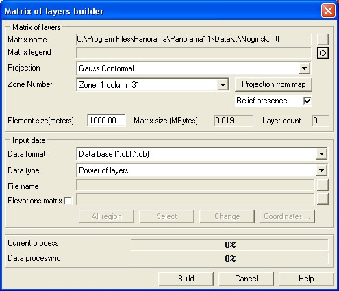
It is necessary to choose the conforming type of input datas and to indicate the name of the indispensable table in File name field in Input data group at construction the matrix of layers by the database table. The name of a created picket map is set automatically by a name of the database table. The classifier of a created map undertakes from standard GIS Panorama delivery. If necessary the user may change names of picket map and classifier by using the appropriate dialog items.
The program of building will make the structure analysis and will produce the information about quantity of matrix layers and supposed number of monitoring picket points. The table fields should correspond to the semantic characteristics of the choosen classifier. The map of pickets is the intermediate information and so it can be not saved, for this purpose it is necessary to switch off sign Create map. If it necessary to view the classifier contents or to do any changes in it, it is necessary to press Change classifier button. The conformity of the database fields to the semantic characteristics of the classifier is set ant geomonitoring pickets plotting on a map is doing at matrix creation. The control of this process is run in Geocoding dialog. Geocoding is called automatically at pressing Build button. The coordinate system of the storable in the database table information, is indicated by the user by choosing from the available variants. There is the Coordinate system element is stipulated in dialog for these purposes. Indicate the matrix name in Matrix of height dialog item for receiving the information about relief from matrix of height at the matrix of layers building .
|