Load matrix from SRTM, GeoTIFF, IMG format |


|
|
The task is intended for loading a matrix of heights from formats SRTM, GeoTIFF, IMG, DEM, KMZ, ADF. Format SRTM - radar topographical surveying of a greater part of globe territory, except for the most northern latitudes (> 60), the most southern latitudes (> 54), and also for the oceans, made by means of special radar system. Data extend by squares in the size 1х1 degree, at the maximal accessible resolution in 3 arcseconds such square is a matrix by the size of 1201х1201 elements (pixels). Reference-ellipsoid of data - WGS 84. Source data of procedure are the files with HGT extension, corresponding to one-degree block of globe territory. Names of files are formed in view of a binding of the left bottom corner of a matrix. As a result of the program work the file in MTW format is formed. Geodetic parameters (type of spheroid, a projection and coordinate system) of a created matrix are taken from the source map for which the loading of the information is carried out. Also there is possible a processing of files TIFF (GeoTiff) and IMG, containing the data about height. Loading the pyramid of matrixes of heights of relief from KMZ format is supported. The imported KMZ archive contains a KML file and a set of single-band GeoTIFF files with elevation data. The KML file contains the description of data - the names of files with the coordinates of a binding of matrixes of heights, and also the priority of their rendering. As a result of importing a pyramid of matrixes of heights of a relief from KMZ the set of MTW files is formed combined into MPT project. Optimal displaying a pyramid of matrixes is achieved by automatically setting the scale of visibility range of MTW matrixes in accordance with the "Draw Order" parameter. ArcInfo Binary Grid files can contain a digital elevation model, a slope model, and a relief shading. The digital model of a relief ArcInfo Binary Grid is stored in binary files *.ADF. Data in binary files ADF is organised in the form of a regular grid. The digital model of a relief contains elevation data as a cell value of regular grid. According to digital model of a relief the matrixes of heights MTW are formed. To store a relief shading, the value of the regular grid cell corresponds to the degree of illumination. The files containing a relief shading or model of slopes, are converted into matrixes of qualities MTQ.
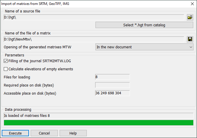
For converting matrixes from formats SRTM, GeoTIFF, IMG into MTW format it is necessary: 1. To download data from Internet. The most part of data is accessible free of charge through FTP: - http://www2.jpl.nasa.gov/srtm/dataprod.htm; - http://dds.cr.usgs.gov/srtm/. 2. To unpack the received files. Names of source files cannot be changed, because in the name the parameters of a binding a matrix are coded. For example, for file N57E038.HGT the binding is equal 57 degrees of northern latitude and 38 degrees of east longitude. 3. To run the task. The task is carried out by Srtm2Mtw.dll module which is called through Run application item of the Tool menu or by means of the menu item File\Import rasters or matrix from...\Matrix (SRTM, GeoTIFF, IMG). 4. To select one or more source files with HGT extension 5. To specify a folder for placing the results of data loading. Name of the output file (MTW format) is formed by name of the source file. 6. To interpolate the missing values of heights click the button Calculate elevations of empty elements. By means of a method named as radar interferometry a huge amount of information on a relief of the Earth has been collected. However, in some cases the mathematical apparatus of the method can not determine the value of height of the individual elements of a matrix. To such elements the NODATA value (there are no data) is given. Similar misses in data are undesirable for further use and processing a matrix of heights. In the program the elimination of undefined heights by a method of linear interpolation of the neighboring known values is stipulated. 7. To choose from the drop-down list «Opening of the generated matrixes MTW» a mode of adding the loaded matrixes (MTW format) into the map document. Following variants are possible: to open matrixes in the new document, to add matrixes into the current document, to not open a matrix. 8. For formation of the transaction log, click on the button "«Filling of the journal SRTM2MTW.LOG». SRTM2MTW.LOG file is created during loading matrixes in the \LOG folder in directory of output matrixes. 9. For formation of survey images of a target matrix, click the button «Creation of a survey image». If you do not use this mode, creation of survey images of a matrix will be performed automatically at its displaying in the document. 8. To press the Execute button. During loading data, the program reads the value of height of a current element of a matrix and places the information into a resulting matrix (file *.MTW). |