Formation of the passport for the nomenclature sheet |


|
|
When the task Formation of the nomenclature sheet is performed for a set of digital topographical maps of the original scale, one sheet of the map for the corresponding derived scale is automatically generated: - for 4 sheets of scale 1: 25 000 – 1 sheet of scale 1: 50 000; - for 16 sheets of scale 1: 25 000 – 1 sheet of scale 1: 100 000; - for 4 sheets of scale 1: 50,000 – 1 sheet of scale 1: 100,000.
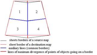
The selection for the map sheets of the original scale is performed automatically from the nomenclature for the map sheet of the derived scale. In this case, a sheet frame and auxiliary lines (vertical and horizontal) are added to the sheet of the derived scale map. Vertical lines run along the mating vertical sides of the frames for the map sheets of the original scale. The horizontal line is along the mapped horizontal sides of the frames for the sheets of the original scale map. Stapling of objects, in the future, is performed along auxiliary lines.
Scheme of united sheets of topographic maps:
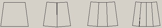
Usually the border of the topographic map sheet has 5 points (taking into account the point of closing). Depending on the sheet assembly, the border of the destination map may have additional points (border deflection points). The border of doubled sheet has 7 points (2 points of deflection), the border of the triple sheet - 9 points (4 points of deflection), the border of the quadruple sheet - 11 points (6 points of deflection). The sheet assembly depends on the latitude of the region: - zones A - O - a single sheet; - zones P - S - a doubled sheet; - zones T - U - a quadruple sheet (a triple sheet for scale 1: 200 000).
Schemes of sheets assembly of topographic maps:
|