Technology of generalization |


|
|
Generalization of DTM is used to transform the map of the original scale into a map of a smaller (derived) scale.
The process for map transformation consists of a number of stages: - formation of nomenclature map sheet of output scale; - encoding of objects (change of the classifier); - generalization of hydrography and hydraulic engineering constructions; - generalization of built-up area; - generalization of objects of small length or the area; - checking of adjacent sheets objects.
The technology of generalization is realized in the form of an application of the GIS Panorama program.
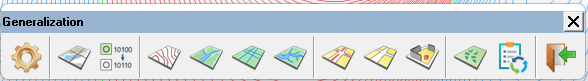
General view of the panel «Generalization»:
The detailed description of technology is contained in the document ...\Doc\Generalization of topographic maps.doc (in the subdirectory of the installed program).
Formation of nomenclature sheet of a map of destination scale is carried out in the catalog of the source map with a name corresponding to the nomenclature of output sheet. At the end of the formation of the nomenclature sheet of the destination scale, a mathematical grid is created. At recoding of objects a change of the map classifier is carried out. The destination map is formed in the embedded directory of the source map (Topogen). The name of the map passport is saved. For example, the source map with the name c:\Data\O-45-01.map is saved with the name c:\Data\Topogen\O-45-01.map. Further processing is performed in the same directory (Topogen). When performing the generalization of built-up area, a service map with the SIT extension is automatically created. At execution of each stage following the formation of the mathematical grid, backup copies of the destination and service map in the SXF format are automatically saved. The name of the SXF file corresponds to the name of the MAP file with addition of the number of copy (c:\Data\Topogen\O-45-01_1.sxf). The copy number corresponds to the ordinal number of the completed generalization stage. The order of the stages execution (with indicating the start time) is recorded into registration list of generalization processes (Generalization Parameters dialog). Restoration of data at the moment of the execution beginning (a restoration point) of one of the previous steps is made in the Generalization Parameters dialog. For choosing a point of restoration it is necessary to select a line in the registration list of generalization processes and to click the Restore button. Thus, it is possible to re-process the map with changing input parameters, and also to restore the map at abnormal termination. Restoration of data at the moment of starting the execution of recoding is not required, because the state of the derivative map obtained at the end of the formation of the nomenclature sheet (at execution of further generalization processes) is saved. To return to the beginning of the recoding, you must open the corresponding map in the source directory.
|