Land plots |


|
|
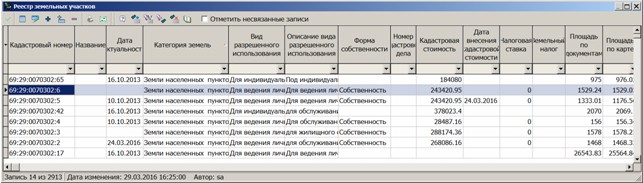
The form of the register list of land plots is intended for viewing, editing, adding, deleting the accounts of land records, as well as for linking them with the cadastral map. There is supported a conducting the table of land plots of a database of the GIS «Land and real estate» and «Workstation of urban planner».
The form of land plots list:
On the form of the ground areas list the additional functional buttons of linking the ground area with a map are available:
Mark unlinked records - customizing the appearance of the list. If the box is checked, then all unlinked registry records are marked in pink. Specialised command buttons:
- Category of land; - The composition of the type of permitted use; - Type of law; - Status of land plot;
When working with large lists, it is convenient to use service of tabular search and filter.
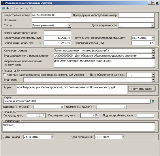
The form of representing the detailed data about the land plot is shown in the Figure. Cadastral number - cadastral number of the land plot. Previous cadastral number - old cadastral number. Name - the conventional name of the land plot. Status - the registration status of the land plot, selected from the reference «Land plot status». Actuality date - date of actuality of the provided information on the land plot. Number of cadastral file - number of the land plot file. Cadastral cost - cadastral cost of a land plot. Date of entering of cadastral cost. Tax rate - rate size in %. Land tax - the amount of land tax in rubles is calculated using the formula 3H = KC * HC / 100, where KC is the cadastral cost, HC is the tax rate in%. For automatic calculation the button Land category - a land category that characterizes a given site. Selected from the directory «Land category». Kind of permitted use - the code and value are selected from the directory «Content of permitted use». Permitted use by document - additional information about the kind of permitted use of the land plot. Presence of registered rights to the land plot, date of data update - is filled automatically in the presence of the rights. It is not edited. Kind of right - Selected from the directory «Kind of right». Address - the address of the land plot. The address can be specified in any form or obtained from the Address register of the cadastral database by clicking the Get address button. Map - If a land plot card is associated with an object on the map, the name of the map and the object number are entered into the field. When you press the Area by documents - the area of the plot indicated in the title deeds. Area by map - the area of the plot on the map, is filled in automatically if the plot is associated with a map object. Building area - the area of the land plot under building. Start date - the date of the beginning of the land plot accounting. The date can be entered into the field in the format dd.mm.yyyy or selected from the auxiliary drop-down window. If not specified, it is filled in automatically with the current date. End date - the date of completion of the land plot. The date can be entered into the field in the format dd.mm.yyyy or selected from the auxiliary drop-down window. It is automatically filled in with the date 01/01/2079.
Form of land plot detailed information:
By pressing the button The
To print detailed information about the land plot record, use the button Buttons «<» «>» - allow you to navigate through the registry records from the form of editing record. |