Object intersection calculation |


|
|
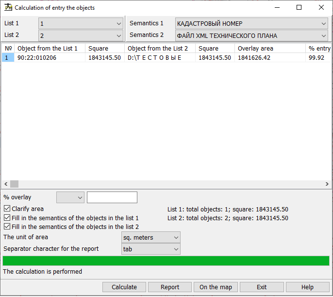
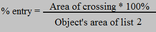
Result of the mode operation are the calculated values of the areas of objects entry of the list 2 (control objects) onto objects of the list 1 (analyzed objects). The program determines the multiple entries of objects of list 2 into input objects of the list 1 and calculates the area of each entry in absolute units, and as a percentage of the object of overlay. To start calculations, you must select the lists of objects in the drop-down menus and click the «Calculate» button. Different lists should be selected. Results of calculation of multiple overlay will be shown in the table. As the identification information, displayed in fields of the table «Object from the List 1» and «Object from the List 2», there is used the semantics chosen in drop-down lists «Naming semantics». These lists are formed from the list of semantics of the first object of the corresponding list (the first object of the map that has the minimum number in the list of maps). If the semantics «Name» (code 9) is not found in the list of semantics, it is forcibly written into the end of the list. In the fields of the table with the name «Square», the areas of objects from the list 1 and list 2, respectively, are entered. In the «Crossing area» field there is recorded the area of crossing the object of the list 1 with the object of the list 2. In the field of the table «% entry» there is written in percentage, which part of the object of list 2 is included into the object of list 1. The formula used in the calculation is such:
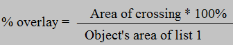
In the field of the table the «% overlay» there is written in percentage, which part of the object of list 1 is imposed onto object of the list 2. The formula used at calculation is such:
This field can be used to filter the contents of the table. The filter settings elements are located below the table and include a drop-down menu for selecting a filtering condition and a field for entering a filtering value. Following conditions are available: «equal to», «not equal to», «greater than», «greater than or equal to», «less than», and «less than or equal to». After setting the conditions and values in the filter, it is necessary to perform the calculation again by clicking on the «Calculate» button. For unloading data into a CSV or XLS file, click the «Report» button. The dialog allows you to select the type of delimiter that will be used when uploading data to a CSV file. The data is unloaded taking into account the filter settings. Also, after performing the calculation, it is possible to write into the objects of list 1 and of list 2 the data about what objects from the other list enter the object, and also the the crossing area and the percentages of entry and overlay. For this purpose it is necessary to choose at first in objects of which lists it is necessary to fill semantics, by specifying the check-boxes «Fill in the semantics of the objects in the list 1» and «Fill in the semantics of the objects in the list 2». If after the last calculation the status of these check-boxes has been changed, then you need to perform the calculation once again. After this, by pressing the «On the map» button, semantics filling is made. The map must be created using the agro10t.rsc classifier. When the check-box «Fill in the semantics of the objects in the list 1» is set, the calculation results are saved in the form of group of repeated semantics of objects of the list 1: · Semantics 637 «Crossing with object» - the name of object from the column «Object from the List 2»; · Semantics 639 «Crossing area» - a column «Crossing area» in hectares; · Semantics 638 «Percent of entry» - a column «% entry»; · Semantics 640 «Percent of overlay» - a column «% overlay». When the check-box «Fill in the semantics of the objects in the list 2» is set, the calculation results are saved in the form of group of repeated semantics of objects of the list 2: · Semantics 637 «Crossing with object» - the name of object from the column «Object from the List 1»; · Semantics 639 «Crossing area» - a column «Crossing area» in hectares; · Semantics 638 «Percent of entry» - a column «% entry»; · Semantics 640 «Percent of overlay» - a column «% overlay». If one of the check-boxes was not selected, the previously filled semantics of list objects with codes 637-640 will be cleared. Tag «Clarify area» carries out information function and is not available for change, it duplicates the value of the tag «Precise square and length» from the «Options» section of the main menu of the program.
|