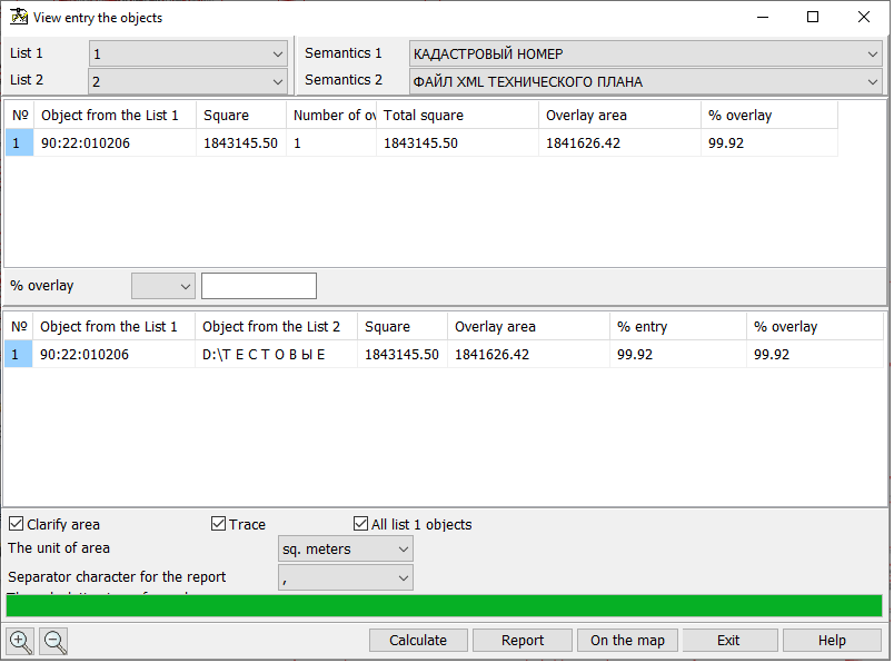
View object intersection |


|
|
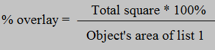
Result of the mode operation are the calculated values of the areas of objects entry of the list 2 (control objects) onto objects of the list 1 (analyzed objects). The program determines the multiple entries of objects of list 2 into input objects of the list 1 and calculates the area of each entry in absolute units, and as a percentage of the object of overlay. To start calculations, you must select the lists of objects in the drop-down menus and click the «Calculate» button. Different lists should be selected. The drop-down lists «Naming semantics» are filled with the semantics of the first object of the corresponding list. The first object is the first map object that has the smallest number in the list of maps. If the semantics «Name» (code 9) is not found among the semantics, it is forcibly written into the list. The results of the calculation of multiple overlay will be shown in two tables. The first table shows the list of objects of the list 1. The fields of the table contain the following information: - «Object from the List 1» - the value of semantics chosen in the ««Naming semantics»» drop-down list; - «Square» - the area of object of the list 1; - «Number of overlays» - the number of objects from list 2, intersecting with an object from list 1; - «Total square» - the total area of all objects from list 2 intersecting with the object from list 1; - «Crossing area» - the area of intersection with all objects from list 2; - «% overlay» - a part of object of the list 1 in percentage which is imposed on all objects from the list 2. It is calculated by the formula:
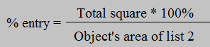
This field can be used to filter the contents of the first table. The filter settings elements are located below the table and include a drop-down menu for selecting a filtering condition and a field for entering a filtering value. The available conditions are «equal to, «not equal to», «greater than», «greater than or equal to», «less than», and «less than or equal to». After setting the conditions and values in the filter, it is necessary to perform the calculation again by clicking on the «Calculate» button. The second table is linked to the first table, and changes its contents when moving through the rows of the first table. It contains the list of objects from the list 2 that have crossing with the object selected in the first table. Table fields contain the following information: - «Object from the List 1» - the semantics value from the «Naming semantics» drop-down list selected in the first object table from list 1; - «Object from the List 2» - the value of semantics from the drop-down list «Naming semantics» of object from the list 2; - «Square» - the area of object from the list 2; - «Crossing area» - the area of intersection of the object from list 2 with the object selected in the first table from list 1; - «% entry» - a part of object 2 in percentage which is included into object of list 1, which is chosen in the first table. It is calculated by the formula:
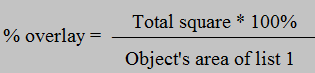
- «% overlay» - a part of object of the list 1 in percentage which is imposed on objects from the list 2. It is calculated by the formula:
Tag «Clarify area» carries out information function and is not available for change, it duplicates the value of the tag «Precise square and length» from the «Options» section of the main menu of the program. If the «Trace» check-box is used, while moving through the first table, the map will be positioned on the object selected in the table, and this object will be highlighted on the map. The «All list 1 objects» check box controls the filling of the first table. If it is set, even those objects of list 1 that have no crossing with any object from list 2 will be added to the table. To unload data from the first table to a CSV or XLS file, click the «Report» button. The dialog allows you to select the type of delimiter that will be used when uploading data to a CSV file. The data is uploaded taking into account the filter settings. Also, after the calculation, it is possible to write into the objects of list 1 data on how many objects from list 2 are included in the object, as well as their total area and the total crossing area. By clicking on the «On the map» button, the semantics are filled. The map must be created using the agro10t.rsc classifier. The number of objects from list 2 that intersect with the object from list 1 is written into the «Number of overlays» semantics (code 641) of the object. The total area of objects of the list 2 that intersect with the object in list 1 is written into the «Area of control objects, ha» semantics (code 642). The semantics «Total area of intersection, ha» (code 643) contains the total area of intersection of the objects of list 2 with the object of list 1.
|