Formation of XML-document on the establishment of Zones |


|
|
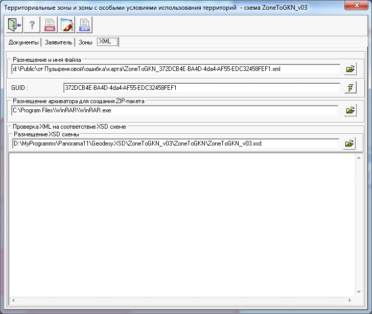
The name of XML-file of the document should have the following view: ZoneToGKN _ *.xml (for example, ZoneToGKN _589D2D56-06BA-4bb1-83D5-7815DF0042A1.xml), where ZoneToGKN - prefix denoting a file with information of the document; * - the unique set of characters corresponding to the GUID.
The formed document should be included into the ZIP package. One document corresponds to one package. The package name should have the following view: ZoneToGKN_*.zip, where ZoneToGKN - prefix denoting a file with information of the document; * - the unique set of characters corresponding to the GUID, specified in XML-file of the document. The package contains XML-file of the document and one or several XML-files of maps-plans, and also PDF-files of images of attached documents. XML-files of maps-plans should be created by means of the mode Forming the XML-document is made in accordance with the XML-scheme ZoneToGKN _v03.xsd placed in the folder the Geodesy.XSD. Presence of this data for program functioning is obligatory, so as in the specified folders the required classifiers and directories are contained. The recommended operations procedure:
- To fill the positions of the screen's form on pages "Documents", "Declarant" and "Zones". - To form the XML-document ( - To form an electronic digital signature (the button - To form the Package of the information for sending to the state cadastre of real estate (the button
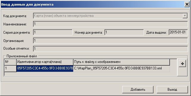
On page «Documents» it is required to specify requisites of the XML-document reproducing the required information for inclusion into the state cadastre of real estate that is passed to the cadastral authority and to generate lists of attached documents. To write down lists of attached documents, it is necessary to press the button In the section «Declarant» you must specify the declarant and fill the active fields for this declarant. If information about the object of land management (territorial zone or the boundary of the territory) is provided on behalf of the declarant by his confidant, in the dialog you must set the flag «Agent». In group «Agent» the mandatory requisites for filling are: surname, name, post, and also information about the document proving the identity. Postal address - is an optional requisite for the declarant and the agent. At filling the information on the address the mandatory requisite is the «Region Code» which is selected from the directory dRegionsRF_v01.xsd. The attributes characterising the address of object of land management are used in a complex at XML-document filling. For address attributes, for which the value type is provided, input of semantics should be conducted by pairs (for example: a name and type of city, street and type of street). In order to write down the address attribute into file XML, it is necessary to enter value of an address element (area, settlement, street, house, building, structure, apartment) and to specify the type. Types without values are not written into the files. On «Zones» page the type of zones changes is selected and the list of zones is formed by the button In dialog the «Element - Zone» the obligatory requisites for filling are: «Name of object», «Cadastral district», «Zone kind» (by the classifier), «Number», and also section «Locations of object of land management». «Zone kind» is selected from the directory _Zone_v02.xsd.xsd. Into the «Locations of object of land management» section the objects addresses are written down. To call the dialog for formation of the addresses list it is possible by the button For «Territorial zone» the obligatory element for filling is the «Type of permitted use», and in this element the obligatory requisite for filling is the «Permitted use». «Permitted use (by nomenclature)» is filled from the directory dUtilizations_v01.xsd. For «Zones with special conditions of use of territories (Types of permitted use)» the obligatory element for filling is the «Zone with the specific terms of use». In dialog the «Element - Zone» it is necessary to add the information about XML - file generated earlier in the task «Forming XML-document of a map (plan) of object land». Pressing the button «Map (plan)» opens the dialog for filling the data about the document - a map (plan). By the button
At the exit from the mode, the entered data is automatically saved in XML-file which name is specified on page «XML». Information about a file name is saved in the INI-file of an open map. At reopening the mode «Territorial zones and areas with special conditions for use of territories - scheme ZoneToGKN» information from the XML-file will be automatically read and displayed in corresponding elements of dialog. |