Export territorial planned data in GML |


|
|
The converter is used to export maps into documents of territorial planning in GML format.
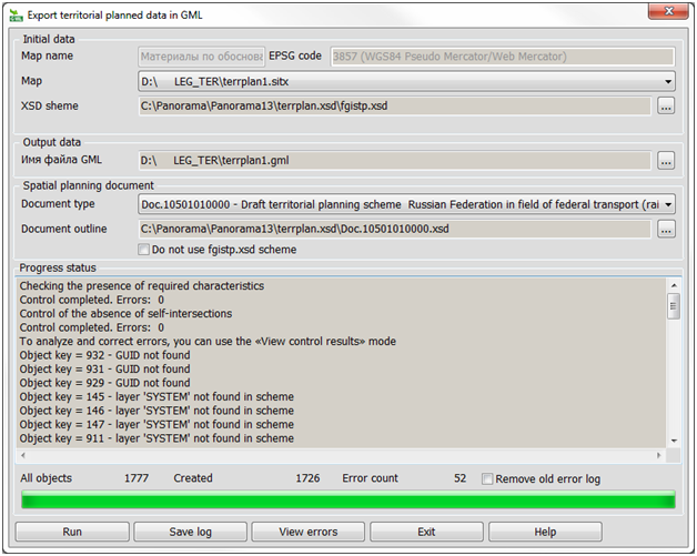
In the field «Initial data» the processed map is selected. The drop-down list contains open maps which were created on the basis of the classifier of territorial planning terrplan.v5.rsc. In case in a set there is no map of territorial planning, the corresponding message is given. If the set contains maps with different classifiers, then only those suitable for the converter will be included in the drop-down list. Select the map to be exported from the «Map» drop-down list. For correct placement of data on the FGIS TP portal, spatial data are prepared in the EPSG:3857 coordinate system with utf-8 encoding. When loading cartographic data into the FGIS TP system, you must select from the list the coordinate system in which the vector data were prepared - EPSG:3857. In the «Save to GML file» field, the «…» button selects the name of the resulting file. In the field «Spatial planning document type», the resulting format of the GML document is selected in accordance with the order of the Ministry of Economic Development of the Russian Federation of December 7th, 2016 N 793 «On approval of requirements for the description and display in documents of territorial planning of objects of federal significance, objects of regional significance, objects of local significance»: -Doc.20301010000 - Regulations on the territorial planning of the urban district; -Doc.20201010000 - Regulation on the territorial planning of the settlement; -Doc.20101010000 - Regulation on the territorial planning of the municipal district; -Doc.10804010100 - Regulations on the territorial planning of the city of federal significance; -Doc.10803010100 - Regulations on the territorial planning of the subject of the Russian Federation; -Doc.10506010100 - Scheme of territorial planning of the Russian Federation in the field of health care; -Doc.10505010100 - Scheme of territorial planning of the Russian Federation in the field of higher education; -Doc.10504010100 - Scheme of territorial planning of the Russian Federation in the energy industry; -Doc.10502010100 - Scheme of territorial planning of the Russian Federation in the field of federal transport (in terms of pipeline transport); -Doc.10501010100 - Scheme of territorial planning of the Russian Federation in the field of federal transport (rail, air, sea, inland waterways) and federal highways.
In the field «Process status» in the top bar the general process of export is displayed. The number of processed objects, errors and all objects are displayed in the corresponding fields. The list of errors is saved in a log, which is a text file. The log is located in the log folder with the map and has the «.gml.log» extension. The name of the log file matches the name of the GML file into which export is carried out.
The composition of objects and their attributes is controlled for compliance with the fgistp.xsd scheme, taking into account the type of formed document. The objects metric is controlled for the absence of self-intersections, repeated points and the correct placement of multipolygons. Point objects are controlled for placement over polygons of the same layer with them. Unique object identifiers are controlled for non-repeatability and conformity to the GUID format. The updated data control allows you to correct the following types of errors detected by FSIS TP: - The file does not contain the "Geometry" field, or the description of the geometry (tags) is indicated with errors; - The file was prepared in violation of the requirements of the Order of the Ministry of Economic Development of Russia dated 09.01.2018 № 10. The attribute «Unique identification number» (GLOBALID) has an incorrect value; - Error of transformation of the coordinate system selected by the user into the coordinate system used in FSIS TP; - The file was prepared in violation of the requirements of the Order of the Ministry of Economic Development of Russia dated 09.01.2018 № 10 / Order of the Ministry of Economic Development dated 07.12.2016 № 793: There is no mandatory field "Object status"; - The object has an error in the created polygon - Hole lies outside shell in the point; - The object has an error in the created polygon - there are few points in the point.
In case of errors, it is suggested to continue or stop processing. The control results can be viewed in the task window and saved for further analysis («Save log» button). In addition, the control results are automatically recorded in the service protocol, which allows, upon completion of the program execution, to perform automatic search and localization on the map of the locations of detected errors and greatly facilitates the process of their correction. Errors can be viewed immediately upon completion of the procedure (the «View errors» button) or later by clicking a special button on the "Electronic Document Flow" toolbar of the Complex of urban tasks
In the task of Export of territorial planned data in GML, automatic division of a territorial planning scheme into several GMLs (from 1 to 3) is implemented if there are several localizations in one scheme layer (linear, areal, point). So as without division onto different GMLs, the error "unified approach is violated when describing the type of geometry" is given. All files will have the same name as the map being saved, with addition to a name of lines .#1-3, .#2-3, .#3-3 (if 3 files are created). For example (for 2 files): "Map of planned placement of objects.#1-2.gml", "Map of planned placement of objects.#2-2.gml". If there is only one localization in each scheme layer (different layers can have different localizations), then division into several files is not performed. So as FGIS TP does not support objects of the multipolygon type (MultiSurface) in GML, then when areal objects with several external contours (multipolygons) are saved in GML, automatic splitting into separate polygons is performed with the update of the new parts of semantics 800 (GUID) and 1265 (object area) .
|