Setting the boundaries of rivers visibility |


|
|
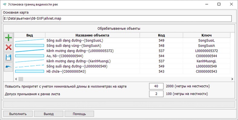
The task Setting the boundaries of rivers visibility is called through the Run Application item of the Tools menu. This mode is intended for simplification of a hydrographic network in map scales of 50 000 and 100 000. The purpose of simplification of a hydrographic network is appointment to concrete objects of a hydrographic network of a range of the visibility corresponding to their degree of the importance. Degree of the importance of the rivers is defined in the length and character of its location relative to other rivers. In this task, two categories of objects are considered: priority and excluded objects. Priority objects are objects whose visibility will not change. These objects include objects whose length is greater than the established minimum length, located in the tolerance of adherence to the border of the sheet and these objects on both sides adhere to other objects. For rivers having the same semantic characteristic value "Name", their total length will be taken into account. Excluded objects are objects whose upper boundary of visibility will be reduced by 1 level relative to the map scales of 50 000 and 100 000. Such objects include objects whose length is less than the minimum length specified and these objects are adjacent only on one side to another object.
This dialog is presented as a table of processed objects. At work with the table the modes are available:
To increase the priority of objects, it is necessary to set the minimum length and tolerance of adherence to the border of the sheet.
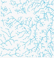
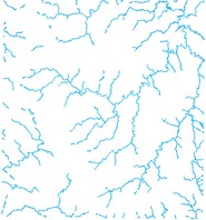
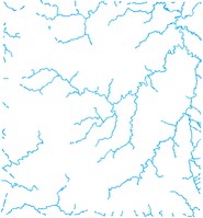
In the figure: at the left - the initial image of the rivers net on the scale of 25 000, in the center - the result of execution of automatic sparseness of a hydrographic net on the scale of 50 000, on the right - result of execution of automatic sparseness of a hydrographic net on the scale of 100 000. |