Forming XML-document of a map (plan) of land management object |


|
|
Map (plan) is always a single XML file that contains the semantic information of the map (plan), and also one or more files with PDF extension, containing a graphic part of a map (plan) and the Applications. The name of XML-file of a map (plan) is formed automatically, in accordance with the requirements of normative documents and has the following form: MapPlan_*.xml, where MapPlan - a prefix denoting a file with information of a map (plan); * - an unique character set corresponding to the GUID. GUID automatically is formed and recorded in XML-file. Attached PDF files should be located in one folder with the XML-file. The path to the files-applications is automatically specified in the XML-document concerning the catalog of placing the XML-file of a map (plan). The names of the directories and file names must not contain special characters such as: + / \* <>@ «” `] [{} $ # ~. Each XML and PDF file should be signed by own electronic digital signature. The file of electronic digital signature should be placed in the same directory as the signed file. The filename of a digital signature should looks like: <name of a signed file>.sig Formed XML-document the map (plan) of land management object is an integral part of information included in the state cadastre of real estate, at implementation of information interaction in the following cases: - regarding information about an establishment or change of boundaries between subjects of the Russian Federation, boundaries of municipal formations, boundaries of settlements (further - Boundaries); - regarding information on establishmen, change, the terminating the existence of zones with special conditions of using the territories, territorial zones (further - Zones). Within the scope of implementation of information interaction the XML-documents and attached PDF files are packed into one ZIP package. The package contains one XML-file for Zones or Boundaries and one or several XML-files of map (plan), and also PDF-files of images of attached documents. For formation of the XML-document describing Zones there is intended the mode Formation of XML-documents is made according to the XML-schemes placed in the folder Geodesy.XSD: - MapPlan_v01 - it is the XML-scheme used for formation of XML-documents at implementation of information interaction at conducting the state cadastre of real estate with public authorities of subjects of the Russian Federation or bodies of local self-government regarding representation of a map (plan) of land management object; - ZoneToGKN_v03 - it is the XML-scheme used for formation of XML-documents at implementation of information interaction at conducting the state cadastre of real estate with public authorities of subjects of the Russian Federation or bodies of local self-government regarding information about the establishment, modification, the termination of existence of zones with special conditions of using the territories, territorial zones; - BoundToGKN_v03 - it is the XML-scheme used for formation of XML-documents at implementation of information interaction at conducting the state cadastre of real estate with public authorities of subjects of the Russian Federation or bodies of local self-government regarding information about the establishment or change of bounds between subjects of the Russian Federation, municipal boundaries, boundaries of settlements. Presence of these data for program functioning is obligatory, because in the specified folders the required classifiers and reference manuals are contained. For forming the XML-document of a map (plan) of land management's object in the environment of "Panorama" it is necessary: - To put onto a cadastral map the original information about the location of land management's object from XML-files of the state cadastre of real estate. - To add into a cadastral map the amendments according to results of field works - to prepare the coordinate description of land management's object. - To Prepare the document "Map (plan) of object of land management" in accordance with the Government Decree of the Russian Federation from July, 30th, 2009 N 621 "On approval of the form of a map (plan) of land management's object and requirements to its drawing up" and to receive its scanned copy in format PDF. - To form the electronic document a map (plan) of object of land management. For convenience of users the call of necessary modes is combined within the scope of dialogue "the Map (plan) of object of land management".
For formation of the text report use the button For formation of the XML-document of a map (plan) of land management's object it is necessary to fill the data in screen forms of dialogue and to press the button At formation of the XML-document a map (plan) of object of land management the following data are used: - about customers of cadastral works; - about the executor organization of the use of land; - about orchestration of a map (plan) of land management object; - about transfer of a map (plan) of object of land management to the State land administration data; - reasons for carrying out the land-management works and source data; - about object of land management; - graphic image of borders plan of land management object.
For convenience of input of attributes by XML-document sections, indicators are arranged into groups. On page "Title" the sections «Customers of cadastral works» and «Data on the executor organisation of the use of land» are filled. The section «Customers of cadastral works» consists of group «List of customers» and fields for data input for one customer. In group «Lists of customers» the list of all customers is displayed.
For filling the list of customers, you must fill at first the information about one customer in the upper part of dialog, and to press the button Data on the executor of cadastral works are recorded in the appropriate group.
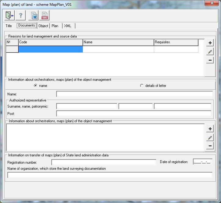
On page the «Documents» the list of documents-reasons for conducting land-management works and source data is formed. To write down lists of documents, it is necessary to press the button
For filling the list of matching, it is required to fill at first the information about one matching in the upper part of group «Information on orchestration of map (plan) of object of land management», and to press the button In group "Information on transfer of map (plan) of State land administration data" received as a result of conducting the land management all fields are obligatory for filling.
On page the «Object» of land management there is carried out input of data about the type of object of land management and input of its attributes, in accordance with the chosen type: zone or boundary. For object of land management with the type of «Zone» the obligatory requisites for filling are: « Name of object», «Cadastral district», «Zone kind» (by the classifier), «Number», and also section «Locations of object of land management». «Zone kind» is selected from the directory _Zone_v02.xsd.xsd.
In the section of «Locations of object of land management» the objects addresses are written down. To call the dialog for formation of the addresses list it is possible by the button At filling the information about the address an obligatory requisite is the «Region» code which is selected from the directory dRegionsRF_v01.xsd. The attributes characterising the address of object of land management are used in the complex at report and XML-document filling. For address attributes, for which the value type is provided, input of semantics should be conducted by pairs (for example: a name and type of city, street and type of street). In order to write down the address attribute into file XML, it is necessary to enter value of an address element (area, settlement, street, house, building, structure, apartment) and to specify the type. Types without values are not written into the files. Input of information about the OKATO Code or KLADR Code is provided in the form of simple input of the symbols characterising the corresponding value code of the All-Russian classifier. Other description of a location of object of cadastral works is used for input of data about the name of noncommercial formation of citizens or other unformalized description of object's location. For «Territorial zone» the obligatory element for filling is the «Type of permitted use», and in this element the obligatory requisite for filling is the «Permitted use». «Permitted use (by nomenclature)» is filled from the directory dUtilizations_v01.xsd.
For «Zones with special conditions of use of territories (Types of permitted use)» the obligatory element for filling is the «Zone with the specific terms of use». For the object of land management with the «Bound» type the mandatory element is «Name of object».
For boundary between subjects of the RF it is necessary to form the list of related subjects of the Russian Federation in the table «Location of borders between constituent entities of the Russian Federation», for boundary of municipality or town border - to fill dialog the «Location of boundaries of settlement» which is activated by pressing For recording into XML-document of the attribute «GeopointOpred» - a method of determining coordinates of a characteristic point, it is necessary for each rotary point to write down the special semantics «Method of determining the characteristic point - the code 1062». On page the «Plan» of borders is formed the list of attached files. The file is selected from the disk by pressing the button When you exit the dialog, the entered data is automatically saved in an XML file whose name is specified on the XML page. Information about a file name is saved into semantics «XML_MAP» of a map object - object of land management. At reopening of dialog the «MAP (PLAN)» for the previously used object, information from the XML-file will be automatically read and displayed in corresponding elements of dialog. |