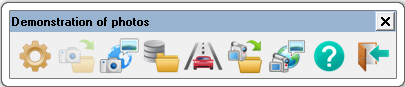
Share your photos with the coordinates of the shooting |


|
|
This set of tasks is intended to display photographs of the terrain and video materials that have a coordinate geotagging to the location of shooting.
Initial data
Photos in the JPEG format with coordinate label. The coordinate label is usually stored in JPEG file in an EXIF-tag. Together with the images, it is possible to receive a project of shooting. The project of shooting is made in the form of a text file and contains a list of photo files with the coordinates of the point and the date of shooting. When the project of shooting arrives, the presence of a coordinate label in the image file is not required.
Video files with GPS-track in AVI, MP4 formats. The track can be contained in the subtitles of the video file, or the file of the same name in the GPX, KML or NMEA-0183 format. The track recorded in a separate file contains the coordinates of the position of the video camera on the ground and the time with an accuracy of 1 second, corresponding to the key frames of the video file.
Links to video streams and network addresses of video cameras. GIS «Panorama» supports work with remote cameras connected to the Internet. The user needs to enter the RTSP link to the video stream or the IP address of the video camera. The functions of viewing the video image, PTZ control of the video camera and obtaining the results of the video analytics built into the camera are available. A demonstration video camera is designed to test the capabilities of working with network cameras.
Panel composition
Movement along the specified route The movement of the track (video) Setting up and viewing a connection to a video camera Help Exit
The panel can be opened from the main menu of the program: Tools - Run applications - Thematic maps and diagrams - Share your photos with the coordinates of the shooting. |